Elected Officials
Courts
Departments
Initiatives
Open Government
About
Login / Register
Home
/
Property & Tax Records
/
Property Records
/
Property & Tax Search
/
Parcel Profile
/
Print View
Search for Another Parcel
Parcel Profile
Historical Card
Sketches
Photos
Tax Map
Taxes
Print View
Print This Page
Address: 7679 WATTSBURG WATERFORD RD
Parcel: 02009022000100
Parcel Profile
Address
7679 | WATTSBURG WATERFORD | RD
Street Status
PAVED
School District
WATTSBURG SCHOOL
Acreage
48.7103
Classification
F
Land Use Code
20 - 79.99 ACRES
Legal Description
7679 WATTSBURG WATERFORD RD 48.7103 AC NET | 53.4297 AC GROSS MANSION LAW SEE PCL 47-21-47-2
Square Feet
1640
Topo
LEVEL
Utility
WELL | SEPTIC
Zoning
Please contact your municipal zoning officer
Deed Book
2021
Deed Page
025560
2026 Tax Values
Land Value / Taxable
64,900 / 64,900.00
Building Value / Taxable
19,900 / 19,900.00
Total Value / Taxable
84,800 / 84,800.00
Clean & Green
Inactive
Homestead Status
Active
Farmstead Status
Active
Lerta Amount
0
Lerta Expiration Year
0
Residential Data
Card 1
Style
OLD STYLE
Basement
PART
Year Built
1890
Exterior Wall
FRAME
Total Living Area
1640
Full Baths
1
Half Baths
0
Fuel Type
OIL
Heating
CENTRAL
Heating System
FORCED AIR
Stories
2.0
Total Bedrooms
3
Total Family Rooms
0
Total Rooms
6
Fireplaces
0
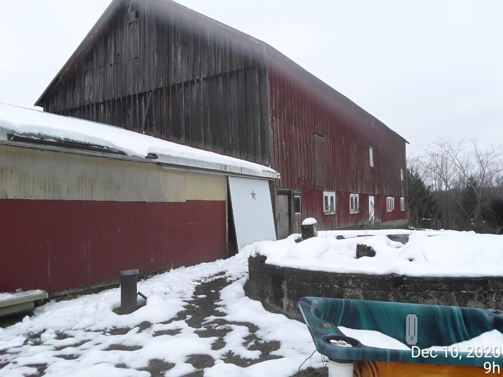
Other Buildings & Yards
Description
Built
Width
Length
Area
BANK BARN
1900
40
80
3200
FR OR CB ATTACHED GARAGE
1900
16
24
384
ONE SIDE OPEN MTL POLE BLDG
1950
40
44
1760
Sales History
Sale Date
Type
Price
Book / Page
Other Info
9/23/2021
LAND & BUILDING
267500
2021 / 025560
DEED
7/15/2004
LAND & BUILDING
0
1154 / 1583
WARRANTY/SURVIVORSHIP DEED
5/27/1992
0
0213 / 1852
1/29/1990
0
0111 / 1368
Parcel Sketches
Residential Card 1
A
MAIN
640 square feet
B
EFP ENCL FRAME PORCH
128 square feet
C
OFP OPEN FRAME PORCH
108 square feet
D
1S FR ONE STORY FRAME
360 square feet
Parcel Images
Please note:
this tab is for informational purposes only and may not show all delinquencies, see the Taxes tab for more accurate delinquent taxes due.