Elected Officials
Courts
Departments
Initiatives
Open Government
About
Login / Register
Home
/
Property & Tax Records
/
Property Records
/
Property & Tax Search
/
Parcel Profile
/
Print View
Search for Another Parcel
Parcel Profile
Historical Card
Sketches
Photos
Tax Map
Taxes
Print View
Print This Page
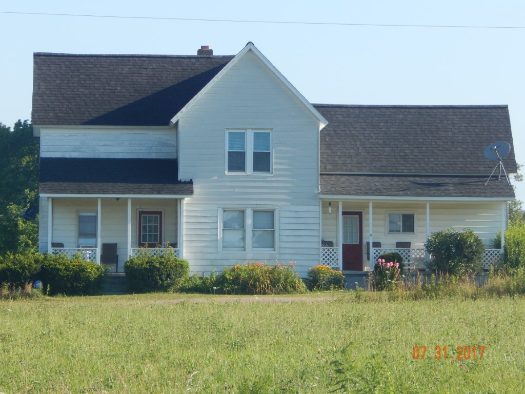
Address: 7900 UNION-AMITY RD
Parcel: 02016023000601
Parcel Profile
Address
7900 | UNION-AMITY | RD
Street Status
SEMI IMPROVED
School District
WATTSBURG SCHOOL
Acreage
9.6590
Classification
F
Land Use Code
10-19.99 ACRES
Legal Description
7900 UNION-AMITY RD 9.659 AC NET | 10.10.512 AC GROSS
Square Feet
1772
Topo
LEVEL
Utility
WELL | SEPTIC
Zoning
Please contact your municipal zoning officer
Deed Book
2016
Deed Page
001911
2026 Tax Values
Land Value / Taxable
30,700 / 6,400.00
Building Value / Taxable
97,200 / 97,200.00
Total Value / Taxable
127,900 / 103,600.00
Clean & Green
Active
Homestead Status
Active
Farmstead Status
Inactive
Lerta Amount
0
Lerta Expiration Year
0
Residential Data
Card 1
Style
CONVENTIONAL
Basement
FULL
Year Built
1900
Exterior Wall
ALUMINUM/VINYL
Total Living Area
1772
Full Baths
1
Half Baths
0
Fuel Type
OIL
Heating
CENTRAL
Heating System
FORCED AIR
Stories
2.0
Total Bedrooms
4
Total Family Rooms
0
Total Rooms
7
Fireplaces
0
Other Buildings & Yards
No OBY Data Found
Sales History
Sale Date
Type
Price
Book / Page
Other Info
1/28/2016
LAND & BUILDING
49087
2016 / 001911
WARRANTY/SURVIVORSHIP DEED
1/28/2015
LAND & BUILDING
0
2015 / 001596
DEED
2/4/1981
0
1411 / 0368
Parcel Sketches
Residential Card 1
A
MAIN
641 square feet
B
OFP OPEN FRAME PORCH
105 square feet
C
EFP ENCL FRAME PORCH
70 square feet
D
OFP OPEN FRAME PORCH
40 square feet
E
UNFIN BSMT BASEMENT UNFINISHED 1S FR ONE STORY FRAME 1/2FR FRAME HALF-STORY
280 square feet
F
OFP OPEN FRAME PORCH
120 square feet
Parcel Images
Please note:
this tab is for informational purposes only and may not show all delinquencies, see the Taxes tab for more accurate delinquent taxes due.