Elected Officials
Courts
Departments
Initiatives
Open Government
About
Login / Register
Home
/
Property & Tax Records
/
Property Records
/
Property & Tax Search
/
Parcel Profile
/
Print View
Search for Another Parcel
Parcel Profile
Historical Card
Sketches
Photos
Tax Map
Taxes
Print View
Print This Page
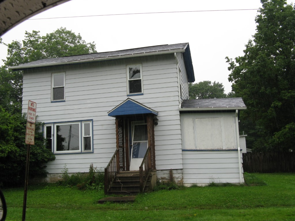
Address: 219 EAST ST
Parcel: 05027180001000
Parcel Profile
Address
219 | EAST | ST
Street Status
PAVED
School District
CORRY AREA SCHOOL
Acreage
0.0892
Classification
R
Land Use Code
SINGLE FAMILY
Legal Description
219 EAST ST TR 52 57.5 X 67
Square Feet
1386
Topo
LEVEL
Utility
PUBLIC WATER | PUBLIC SEWER | GAS
Zoning
Please contact your municipal zoning officer
Deed Book
2021
Deed Page
016850
2026 Tax Values
Land Value / Taxable
5,500 / 5,500.00
Building Value / Taxable
36,600 / 36,600.00
Total Value / Taxable
42,100 / 42,100.00
Clean & Green
Inactive
Homestead Status
Inactive
Farmstead Status
Inactive
Lerta Amount
0
Lerta Expiration Year
0
Residential Data
Card 1
Style
CONVENTIONAL
Basement
PART
Year Built
1930
Exterior Wall
ALUMINUM/VINYL
Total Living Area
1386
Full Baths
1
Half Baths
0
Fuel Type
GAS
Heating
CENTRAL
Heating System
FORCED AIR
Stories
2.0
Total Bedrooms
3
Total Family Rooms
0
Total Rooms
6
Fireplaces
0
Other Buildings & Yards
No OBY Data Found
Sales History
Sale Date
Type
Price
Book / Page
Other Info
6/29/2021
LAND & BUILDING
30000
2021 / 016850
SPECIAL WARRANTY DEED
9/16/2015
LAND & BUILDING
0
2015 / 020364
SPECIAL WARRANTY DEED
5/18/2009
LAND & BUILDING
17000
1562 / 1125
QUIT CLAIM DEED
3/11/2009
LAND & BUILDING
0
1548 / 0294
QUIT CLAIM DEED
Parcel Sketches
Residential Card 1
A
MAIN
456 square feet
B
UNFIN BSMT BASEMENT UNFINISHED 1S FR ONE STORY FRAME AT FN ATTIC-FINISHED
264 square feet
C
EFP ENCL FRAME PORCH
66 square feet
D
1S FR ONE STORY FRAME
104 square feet
E
OFP OPEN FRAME PORCH
12 square feet
Parcel Images
Please note:
this tab is for informational purposes only and may not show all delinquencies, see the Taxes tab for more accurate delinquent taxes due.