Elected Officials
Courts
Departments
Initiatives
Open Government
About
Login / Register
Home
/
Property & Tax Records
/
Property Records
/
Property & Tax Search
/
Parcel Profile
/
Print View
Search for Another Parcel
Parcel Profile
Historical Card
Sketches
Photos
Tax Map
Taxes
Print View
Print This Page
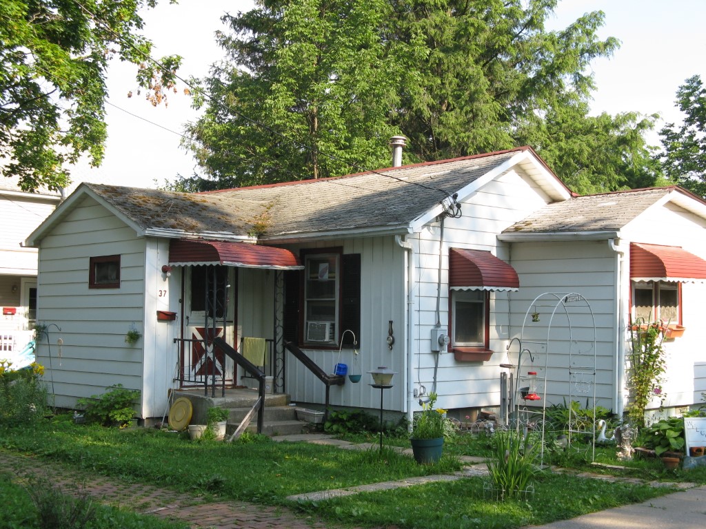
Address: 37 GROVE ST
Parcel: 05032166001100
Parcel Profile
Address
37 | GROVE | ST
Street Status
PAVED | SIDEWALK
School District
CORRY AREA SCHOOL
Acreage
0.2094
Classification
R
Land Use Code
SINGLE FAMILY
Legal Description
37 GROVE ST TR 52 76X120
Square Feet
765
Topo
LEVEL
Utility
ALL PUBLIC
Zoning
Please contact your municipal zoning officer
Deed Book
2024
Deed Page
004410
2026 Tax Values
Land Value / Taxable
6,500 / 6,500.00
Building Value / Taxable
25,120 / 25,120.00
Total Value / Taxable
31,620 / 31,620.00
Clean & Green
Inactive
Homestead Status
Inactive
Farmstead Status
Inactive
Lerta Amount
0
Lerta Expiration Year
0
Residential Data
Card 1
Style
BUNGALOW
Basement
FULL
Year Built
1935
Exterior Wall
ALUMINUM/VINYL
Total Living Area
765
Full Baths
1
Half Baths
0
Fuel Type
GAS
Heating
CENTRAL
Heating System
FORCED AIR
Stories
1.0
Total Bedrooms
1
Total Family Rooms
0
Total Rooms
3
Fireplaces
0
Other Buildings & Yards
No OBY Data Found
Sales History
Sale Date
Type
Price
Book / Page
Other Info
3/22/2024
LAND & BUILDING
70000
2024 / 004410
SPECIAL WARRANTY DEED
3/20/2014
LAND & BUILDING
0
2014 / 004903
TAX DEED
4/11/1983
18000
1490 / 0461
6/12/1971
8000
1045 / 0431
Parcel Sketches
Residential Card 1
A
MAIN
480 square feet
B
UNFIN BSMT BASEMENT UNFINISHED 1S FR ONE STORY FRAME
160 square feet
C
UNFIN BSMT BASEMENT UNFINISHED 1S FR ONE STORY FRAME
48 square feet
D
OFP OPEN FRAME PORCH
20 square feet
E
1S FR ONE STORY FRAME
77 square feet
Parcel Images
Please note:
this tab is for informational purposes only and may not show all delinquencies, see the Taxes tab for more accurate delinquent taxes due.