Elected Officials
Courts
Departments
Initiatives
Open Government
About
Login / Register
Home
/
Property & Tax Records
/
Property Records
/
Property & Tax Search
/
Parcel Profile
/
Print View
Search for Another Parcel
Parcel Profile
Historical Card
Sketches
Photos
Tax Map
Taxes
Print View
Print This Page
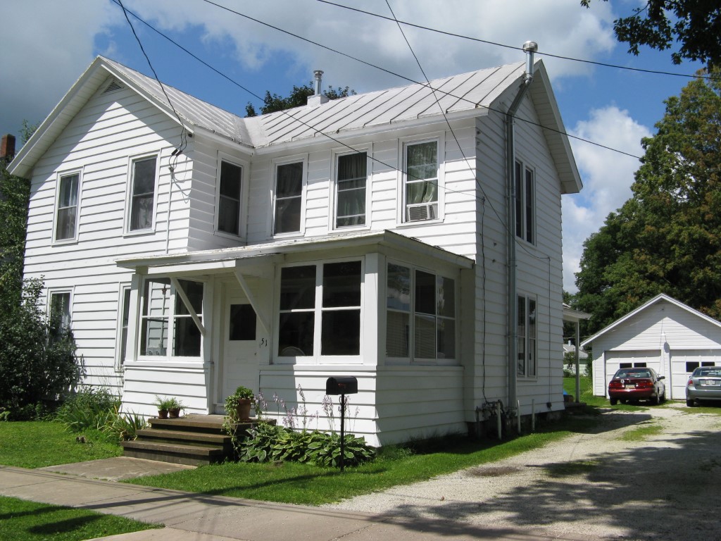
Address: 51 E BOND ST
Parcel: 06015023001600
Parcel Profile
Address
51 | E | BOND | ST
Street Status
PAVED
School District
CORRY AREA SCHOOL
Acreage
0.2428
Classification
R
Land Use Code
TWO FAMILY
Legal Description
51 E BOND ST 187.5X54 IRR
Square Feet
2128
Topo
LEVEL
Utility
ALL PUBLIC
Zoning
Please contact your municipal zoning officer
Deed Book
2012
Deed Page
000531
2026 Tax Values
Land Value / Taxable
12,800 / 12,800.00
Building Value / Taxable
49,350 / 49,350.00
Total Value / Taxable
62,150 / 62,150.00
Clean & Green
Inactive
Homestead Status
Inactive
Farmstead Status
Inactive
Lerta Amount
0
Lerta Expiration Year
0
Residential Data
Card 1
Style
OLD STYLE
Basement
FULL
Year Built
1863
Exterior Wall
ALUMINUM/VINYL
Total Living Area
2128
Full Baths
2
Half Baths
0
Fuel Type
GAS
Heating
CENTRAL
Heating System
FORCED AIR
Stories
2.0
Total Bedrooms
5
Total Family Rooms
0
Total Rooms
11
Fireplaces
0
Other Buildings & Yards
Description
Built
Width
Length
Area
FRAME OR CB DETACHED GARAGE
1960
20
20
400
Sales History
Sale Date
Type
Price
Book / Page
Other Info
1/6/2012
LAND & BUILDING
48000
2012 / 000531
WARRANTY/SURVIVORSHIP DEED
6/15/2010
LAND & BUILDING
0
2010 / 013903
DEED
6/24/2009
LAND & BUILDING
52000
1571 / 0916
DEED
7/20/2006
LAND & BUILDING
44000
1345 / 2336
DEED
8/21/1984
0
1549 / 0179
Parcel Sketches
Residential Card 1
A
MAIN
908 square feet
B
MA STOOP/TERR MAS STOOP
24 square feet
C
EFP ENCL FRAME PORCH
72 square feet
D
1S FR ONE STORY FRAME
168 square feet
E
EFP ENCL FRAME PORCH
54 square feet
F
OFP OPEN FRAME PORCH
75 square feet
G
1S FR ONE STORY FRAME
144 square feet
H
EFP ENCL FRAME PORCH
210 square feet
I
MA STOOP/TERR MAS STOOP
24 square feet
J
MA STOOP/TERR MAS STOOP
720 square feet
Parcel Images
Please note:
this tab is for informational purposes only and may not show all delinquencies, see the Taxes tab for more accurate delinquent taxes due.