Elected Officials
Courts
Departments
Initiatives
Open Government
About
Login / Register
Home
/
Property & Tax Records
/
Property Records
/
Property & Tax Search
/
Parcel Profile
/
Print View
Search for Another Parcel
Parcel Profile
Historical Card
Sketches
Photos
Tax Map
Taxes
Print View
Print This Page
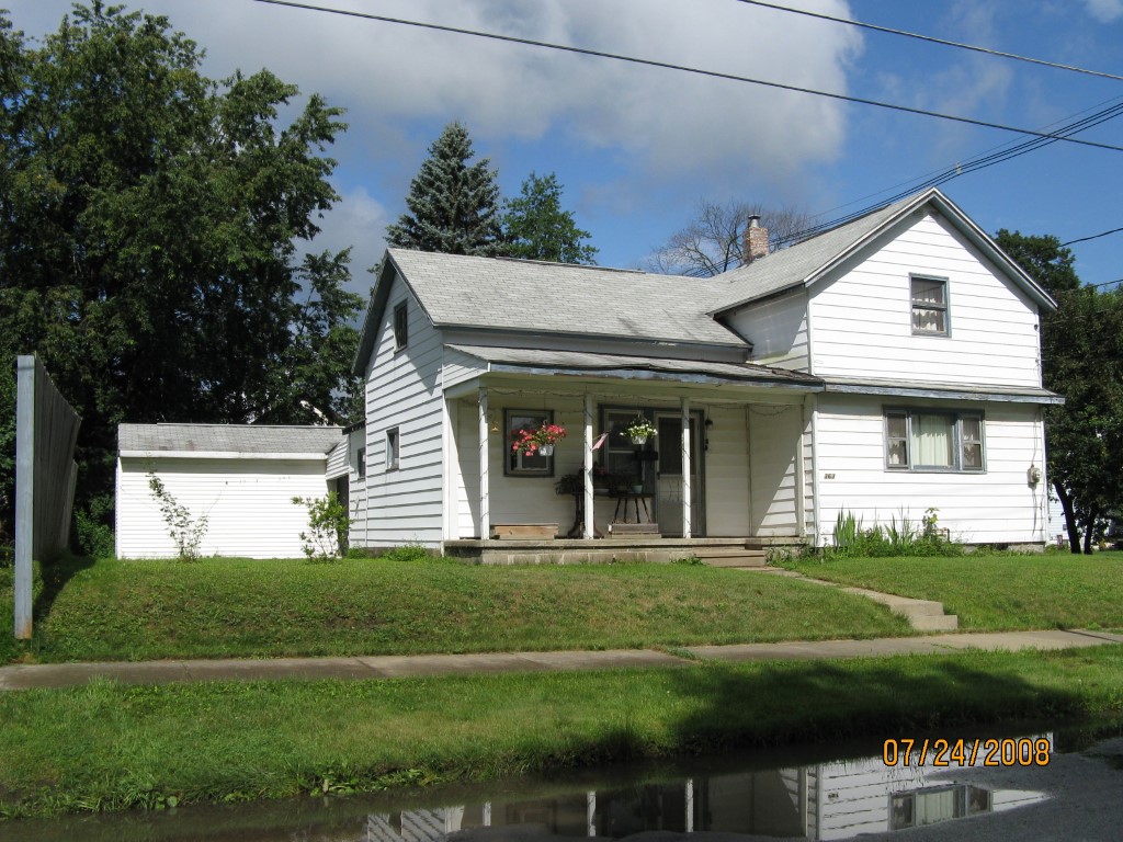
Address: 363 MARION ST
Parcel: 07023064000300
Parcel Profile
Address
363 | MARION | ST
Street Status
PAVED
School District
CORRY AREA SCHOOL
Acreage
0.1474
Classification
R
Land Use Code
SINGLE FAMILY
Legal Description
363 MARION ST TR 51 60X107
Square Feet
1016
Topo
LEVEL | ROLLING
Utility
ALL PUBLIC
Zoning
Please contact your municipal zoning officer
Deed Book
2023
Deed Page
000996
2026 Tax Values
Land Value / Taxable
13,000 / 13,000.00
Building Value / Taxable
37,100 / 37,100.00
Total Value / Taxable
50,100 / 50,100.00
Clean & Green
Inactive
Homestead Status
Inactive
Farmstead Status
Inactive
Lerta Amount
0
Lerta Expiration Year
0
Residential Data
Card 1
Style
CONVENTIONAL
Basement
PART
Year Built
1920
Exterior Wall
ALUMINUM/VINYL
Total Living Area
1016
Full Baths
1
Half Baths
0
Fuel Type
GAS
Heating
CENTRAL
Heating System
HOT WATER
Stories
1.5
Total Bedrooms
3
Total Family Rooms
0
Total Rooms
5
Fireplaces
0
Other Buildings & Yards
No OBY Data Found
Sales History
Sale Date
Type
Price
Book / Page
Other Info
1/19/2023
LAND & BUILDING
0
2023 / 000996
QUIT CLAIM DEED
12/28/2022
LAND & BUILDING
0
2022 / 026827
TAX DEED
1/1/1965
LAND & BUILDING
7500
0919 / 0110
Parcel Sketches
Residential Card 1
A
MAIN
416 square feet
B
OFP OPEN FRAME PORCH
90 square feet
C
1S FR ONE STORY FRAME AT UN ATTIC-UNFINISHED
288 square feet
D
MA_PT CONC/MAS PATIO
77 square feet
E
FR GR FRAME GARAGE
308 square feet
F
OFP OPEN FRAME PORCH
110 square feet
G
EFP ENCL FRAME PORCH
136 square feet
Parcel Images
Please note:
this tab is for informational purposes only and may not show all delinquencies, see the Taxes tab for more accurate delinquent taxes due.