Elected Officials
Courts
Departments
Initiatives
Open Government
About
Login / Register
Home
/
Property & Tax Records
/
Property Records
/
Property & Tax Search
/
Parcel Profile
/
Print View
Search for Another Parcel
Parcel Profile
Historical Card
Sketches
Photos
Tax Map
Taxes
Print View
Print This Page
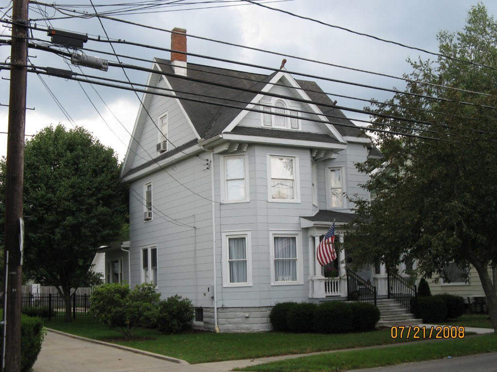
Address: 36 W SMITH ST
Parcel: 07023091000400
Parcel Profile
Address
36 | W | SMITH | ST
Street Status
PAVED | SIDEWALK
School District
CORRY AREA SCHOOL
Acreage
0.1439
Classification
R
Land Use Code
SINGLE FAMILY
Legal Description
36 W SMITH ST PCL 1 49.3X130.5
Square Feet
2127
Topo
LEVEL
Utility
ALL PUBLIC
Zoning
Please contact your municipal zoning officer
Deed Book
2021
Deed Page
017451
2026 Tax Values
Land Value / Taxable
13,000 / 13,000.00
Building Value / Taxable
64,200 / 64,200.00
Total Value / Taxable
77,200 / 77,200.00
Clean & Green
Inactive
Homestead Status
Inactive
Farmstead Status
Inactive
Lerta Amount
0
Lerta Expiration Year
0
Residential Data
Card 1
Style
OLD STYLE
Basement
FULL
Year Built
1900
Exterior Wall
COMPOSITION
Total Living Area
2127
Full Baths
1
Half Baths
1
Fuel Type
GAS
Heating
CENTRAL
Heating System
FORCED AIR
Stories
2.0
Total Bedrooms
4
Total Family Rooms
0
Total Rooms
7
Fireplaces
1
Other Buildings & Yards
No OBY Data Found
Sales History
Sale Date
Type
Price
Book / Page
Other Info
7/6/2021
LAND & BUILDING
0
2021 / 017451
SPECIAL WARRANTY DEED
1/9/1992
0
0191 / 0280
Parcel Sketches
Residential Card 1
A
MAIN
828 square feet
B
UNFIN BSMT BASEMENT UNFINISHED 1S FR ONE STORY FRAME
120 square feet
C
WDDCK WOOD DECKS
234 square feet
D
UNFIN BSMT BASEMENT UNFINISHED MABAY MASONRY BAY
20 square feet
E
OFP OPEN FRAME PORCH
50 square feet
Parcel Images
Please note:
this tab is for informational purposes only and may not show all delinquencies, see the Taxes tab for more accurate delinquent taxes due.