Elected Officials
Courts
Departments
Initiatives
Open Government
About
Login / Register
Home
/
Property & Tax Records
/
Property Records
/
Property & Tax Search
/
Parcel Profile
/
Print View
Search for Another Parcel
Parcel Profile
Historical Card
Sketches
Photos
Tax Map
Taxes
Print View
Print This Page
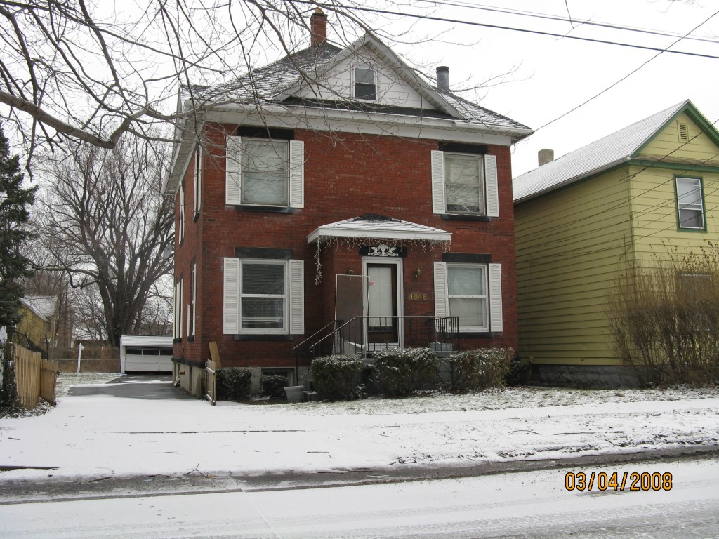
Address: 1848 E 6 ST
Parcel: 14011010023300
Parcel Profile
Address
1848 | E | 6 | ST
Street Status
PAVED | SIDEWALK
School District
CITY OF ERIE SCHOOL
Acreage
0.2988
Classification
R
Land Use Code
SINGLE FAMILY
Legal Description
1848 E 6 ST 80 X 162.65
Square Feet
1800
Topo
LEVEL
Utility
ALL PUBLIC
Zoning
Please contact your municipal zoning officer
Deed Book
1529
Deed Page
0530
2026 Tax Values
Land Value / Taxable
15,500 / 15,500.00
Building Value / Taxable
59,900 / 59,900.00
Total Value / Taxable
75,400 / 75,400.00
Clean & Green
Inactive
Homestead Status
Inactive
Farmstead Status
Inactive
Lerta Amount
0
Lerta Expiration Year
0
Residential Data
Card 1
Style
OLD STYLE
Basement
FULL
Year Built
1911
Exterior Wall
BRICK
Total Living Area
1800
Full Baths
1
Half Baths
1
Fuel Type
GAS
Heating
CENTRAL
Heating System
FORCED AIR
Stories
2.0
Total Bedrooms
4
Total Family Rooms
0
Total Rooms
7
Fireplaces
0
Other Buildings & Yards
No OBY Data Found
Sales History
Sale Date
Type
Price
Book / Page
Other Info
10/31/2008
LAND & BUILDING
39010
1529 / 0530
DEED
7/2/2008
LAND & BUILDING
0
1506 / 1598
DEED
3/3/2008
LAND & BUILDING
0
1479 / 1882
SHERIFF'S DED
12/6/2004
LAND & BUILDING
86000
1195 / 0388
WARRANTY/SURVIVORSHIP DEED
1/29/1999
LAND & BUILDING
66500
615 / 566
4/15/1991
48000
0156 / 0137
6/7/1988
0
0052 / 1997
11/28/1950
0
0581 / 0559
5/28/1943
0
0436 / 0346
Parcel Sketches
Residential Card 1
A
MAIN
900 square feet
B
MA STOOP/TERR MAS STOOP
24 square feet
C
EMP ENCL MASONRY PORCH
32 square feet
D
MA STOOP/TERR MAS STOOP
48 square feet
Parcel Images
Please note:
this tab is for informational purposes only and may not show all delinquencies, see the Taxes tab for more accurate delinquent taxes due.