Elected Officials
Courts
Departments
Initiatives
Open Government
About
Login / Register
Home
/
Property & Tax Records
/
Property Records
/
Property & Tax Search
/
Parcel Profile
/
Print View
Search for Another Parcel
Parcel Profile
Historical Card
Sketches
Photos
Tax Map
Taxes
Print View
Print This Page
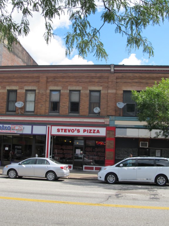
Address: 1021 STATE ST
Parcel: 15020002020900
Parcel Profile
Address
1021 | STATE | ST
Street Status
PAVED | SIDEWALK
School District
CITY OF ERIE SCHOOL
Acreage
0.1514
Classification
C
Land Use Code
RESTAURANTS, STORES (RETAIL)
Legal Description
1021 STATE ST 41.24 X 160 | 0.1514 AC
Square Feet
5586
Topo
LEVEL
Utility
ALL PUBLIC
Zoning
Please contact your municipal zoning officer
Deed Book
2022
Deed Page
007779
2026 Tax Values
Land Value / Taxable
52,800 / 52,800.00
Building Value / Taxable
123,506 / 123,506.00
Total Value / Taxable
176,306 / 176,306.00
Clean & Green
Inactive
Homestead Status
Inactive
Farmstead Status
Inactive
Lerta Amount
0
Lerta Expiration Year
0
Commercial Data
Card 1
DOWNTOWN ROW TYPE
Business Living Area - 3150
Year Built - 1903
Improvement Name - VACANT
Value - 76570
Card 2
DOWNTOWN ROW TYPE
Business Living Area - 2436
Year Built - 1903
Improvement Name - PAPA GEORGE COUNTRY BAR & GRIL
Value - 118110
Other Buildings & Yards
No OBY Data Found
Sales History
Sale Date
Type
Price
Book / Page
Other Info
4/12/2022
LAND & BUILDING
0
2022 / 007779
SPECIAL WARRANTY DEED
10/24/2016
LAND & BUILDING
0
2016 / 022989
SPECIAL WARRANTY DEED
1/29/2016
LAND & BUILDING
185000
2016 / 001994
SPECIAL WARRANTY DEED
4/4/2001
LAND & BUILDING
40000
763 / 1174
2/12/2001
0
0752 / 0786
7/11/1996
45000
0450 / 0194
6/28/1954
0
0678 / 0254
7/1/1941
0
0408 / 0411
Parcel Sketches
Commercial Card 1
A
MAIN
3150 square feet
B
MAIN
3150 square feet
C
MAIN
1890 square feet
Commercial Card 2
A
MAIN
2436 square feet
B
MAIN
2436 square feet
C
MAIN
1260 square feet
Parcel Images
Please note:
this tab is for informational purposes only and may not show all delinquencies, see the Taxes tab for more accurate delinquent taxes due.