Elected Officials
Courts
Departments
Initiatives
Open Government
About
Login / Register
Home
/
Property & Tax Records
/
Property Records
/
Property & Tax Search
/
Parcel Profile
/
Print View
Search for Another Parcel
Parcel Profile
Historical Card
Sketches
Photos
Tax Map
Taxes
Print View
Print This Page
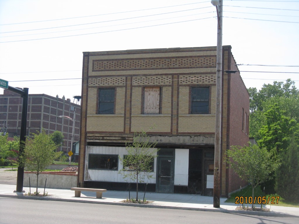
Address: 1318 PARADE ST
Parcel: 15020018010200
Parcel Profile
Address
1318 | PARADE | ST
Street Status
PAVED | SIDEWALK
School District
CITY OF ERIE SCHOOL
Acreage
0.3715
Classification
A
Land Use Code
APARTMENTS 4 - 19 UNITS
Legal Description
1318 PARADE ST 124.5 X 130
Square Feet
6792
Topo
LEVEL
Utility
ALL PUBLIC
Zoning
Please contact your municipal zoning officer
Deed Book
2020
Deed Page
012367
2026 Tax Values
Land Value / Taxable
48,600 / 48,600.00
Building Value / Taxable
226,700 / 56,100.00
Total Value / Taxable
275,300 / 104,700.00
Clean & Green
Inactive
Homestead Status
Inactive
Farmstead Status
Inactive
Lerta Amount
0
Lerta Expiration Year
0
Commercial Data
Card 1
MIXED RES/COMM
Business Living Area - 3000
Year Built - 1919
Improvement Name - HANDS
Value - 38280
Card 2
APARTMENTS - GARDEN
Business Living Area - 3792
Year Built - 2022
Improvement Name -
Value - 175780
Other Buildings & Yards
Description
Built
Width
Length
Area
PAVING ASPHALT PARKING
1980
0
0
12200
Sales History
Sale Date
Type
Price
Book / Page
Other Info
7/7/2020
LAND & BUILDING
180000
2020 / 012367
SPECIAL WARRANTY DEED
6/16/2020
LAND & BUILDING
0
2020 / 010592
SPECIAL WARRANTY DEED
5/5/2005
LAND & BUILDING
85000
1231 / 1981
SPECIAL WARRANTY DEED
1/13/1984
0
1522 / 0209
8/23/1979
0
1361 / 0284
11/30/1948
0
0556 / 0549
11/30/1948
0
0556 / 0551
1/3/1939
0
0390 / 0275
5/21/1935
0
0368 / 0213
Parcel Sketches
Commercial Card 1
A
MAIN
1500 square feet
B
MAIN
1500 square feet
C
MAIN
1500 square feet
Commercial Card 2
A
MAIN
1896 square feet
B
MAIN
1896 square feet
Parcel Images
Please note:
this tab is for informational purposes only and may not show all delinquencies, see the Taxes tab for more accurate delinquent taxes due.