Elected Officials
Courts
Departments
Initiatives
Open Government
About
Login / Register
Home
/
Property & Tax Records
/
Property Records
/
Property & Tax Search
/
Parcel Profile
/
Print View
Search for Another Parcel
Parcel Profile
Historical Card
Sketches
Photos
Tax Map
Taxes
Print View
Print This Page
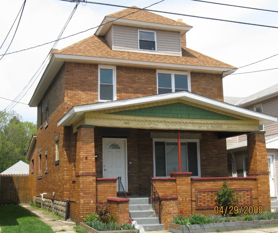
Address: 722 E 11 ST
Parcel: 15020035023200
Parcel Profile
Address
722 | E | 11 | ST
Street Status
PAVED | SIDEWALK
School District
CITY OF ERIE SCHOOL
Acreage
0.1251
Classification
R
Land Use Code
SINGLE FAMILY
Legal Description
722 E 11 ST 33.5 X IRREG
Square Feet
2082
Topo
LEVEL
Utility
ALL PUBLIC
Zoning
Please contact your municipal zoning officer
Deed Book
2016
Deed Page
006385
2026 Tax Values
Land Value / Taxable
6,300 / 6,300.00
Building Value / Taxable
47,600 / 47,600.00
Total Value / Taxable
53,900 / 53,900.00
Clean & Green
Inactive
Homestead Status
Active
Farmstead Status
Inactive
Lerta Amount
0
Lerta Expiration Year
0
Residential Data
Card 1
Style
OLD STYLE
Basement
FULL
Year Built
1917
Exterior Wall
BRICK
Total Living Area
2082
Full Baths
1
Half Baths
1
Fuel Type
GAS
Heating
CENTRAL
Heating System
FORCED AIR
Stories
2.0
Total Bedrooms
3
Total Family Rooms
1
Total Rooms
7
Fireplaces
0
Other Buildings & Yards
No OBY Data Found
Sales History
Sale Date
Type
Price
Book / Page
Other Info
4/1/2016
LAND & BUILDING
50000
2016 / 006385
WARRANTY/SURVIVORSHIP DEED
7/13/2007
LAND & BUILDING
60000
1431 / 1918
DEED
11/2/2005
LAND & BUILDING
0
1284 / 0038
DEED
4/20/2004
LAND & BUILDING
40000
1126 / 1288
WARRANTY/SURVIVORSHIP DEED
9/6/2002
LAND & BUILDING
20000
918 / 342
1/4/2001
0
0746 / 0743
4/5/1999
0
0627 / 0176
7/2/1997
25000
0506 / 2143
1/28/1954
0
0668 / 0238
9/16/1948
0
0524 / 0049
11/3/1943
0
0438 / 0121
Parcel Sketches
Residential Card 1
A
MAIN
800 square feet
B
UNFIN BSMT BASEMENT UNFINISHED 1SMAS MASONRY
322 square feet
C
OMP OPEN MASONRY PORCH
200 square feet
Parcel Images
Please note:
this tab is for informational purposes only and may not show all delinquencies, see the Taxes tab for more accurate delinquent taxes due.