Elected Officials
Courts
Departments
Initiatives
Open Government
About
Login / Register
Home
/
Property & Tax Records
/
Property Records
/
Property & Tax Search
/
Parcel Profile
/
Print View
Search for Another Parcel
Parcel Profile
Historical Card
Sketches
Photos
Tax Map
Taxes
Print View
Print This Page
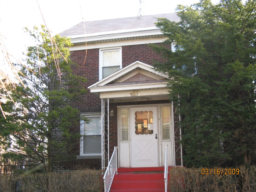
Address: 1711 MOBILE AVE
Parcel: 16030011011400
Parcel Profile
Address
1711 | MOBILE | AVE
Street Status
PAVED
School District
CITY OF ERIE SCHOOL
Acreage
0.1000
Classification
R
Land Use Code
SINGLE FAMILY
Legal Description
1711 MOBILE AVE 40 X 107.50 | 0.10 AC
Square Feet
1560
Topo
LEVEL
Utility
ALL PUBLIC
Zoning
Please contact your municipal zoning officer
Deed Book
2023
Deed Page
015402
2026 Tax Values
Land Value / Taxable
8,900 / 8,900.00
Building Value / Taxable
24,200 / 24,200.00
Total Value / Taxable
33,100 / 33,100.00
Clean & Green
Inactive
Homestead Status
Inactive
Farmstead Status
Inactive
Lerta Amount
0
Lerta Expiration Year
0
Residential Data
Card 1
Style
OLD STYLE
Basement
FULL
Year Built
1924
Exterior Wall
BRICK
Total Living Area
1560
Full Baths
1
Half Baths
1
Fuel Type
GAS
Heating
CENTRAL
Heating System
FORCED AIR
Stories
2.0
Total Bedrooms
3
Total Family Rooms
0
Total Rooms
6
Fireplaces
0
Other Buildings & Yards
No OBY Data Found
Sales History
Sale Date
Type
Price
Book / Page
Other Info
9/13/2023
LAND & BUILDING
0
2023 / 015402
SPECIAL WARRANTY DEED
2/5/2015
LAND & BUILDING
0
2015 / 002189
SPECIAL WARRANTY DEED
8/3/2012
LAND & BUILDING
0
2012 / 020999
QUIT CLAIM DEED
4/18/2008
LAND & BUILDING
0
1489 / 0503
FIDUCIARY DEED
5/23/1967
0
0961 / 0322
Parcel Sketches
Residential Card 1
A
MAIN
780 square feet
B
OFP OPEN FRAME PORCH
24 square feet
C
EMP ENCL MASONRY PORCH
32 square feet
D
EFP ENCL FRAME PORCH OFP OPEN FRAME PORCH
60 square feet
Parcel Images
Please note:
this tab is for informational purposes only and may not show all delinquencies, see the Taxes tab for more accurate delinquent taxes due.