Elected Officials
Courts
Departments
Initiatives
Open Government
About
Login / Register
Home
/
Property & Tax Records
/
Property Records
/
Property & Tax Search
/
Parcel Profile
/
Print View
Search for Another Parcel
Parcel Profile
Historical Card
Sketches
Photos
Tax Map
Taxes
Print View
Print This Page
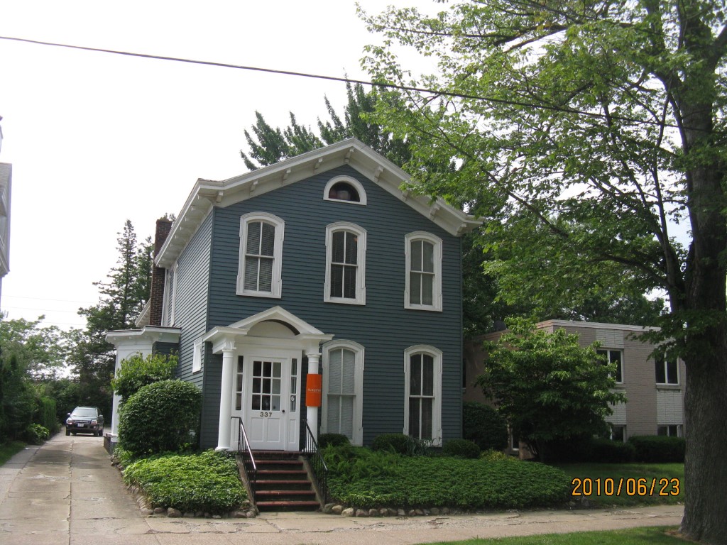
Address: 337 W 10 ST
Parcel: 16030019021400
Parcel Profile
Address
337 | W | 10 | ST
Street Status
PAVED
School District
CITY OF ERIE SCHOOL
Acreage
0.1875
Classification
C
Land Use Code
OFFICE BLDGS/LABS/LIBRARIES
Legal Description
337 W 10 ST 49.5X165
Square Feet
3284
Topo
LEVEL
Utility
ALL PUBLIC
Zoning
Please contact your municipal zoning officer
Deed Book
2025
Deed Page
012073
2026 Tax Values
Land Value / Taxable
16,300 / 16,300.00
Building Value / Taxable
98,300 / 98,300.00
Total Value / Taxable
114,600 / 114,600.00
Clean & Green
Inactive
Homestead Status
Inactive
Farmstead Status
Inactive
Lerta Amount
0
Lerta Expiration Year
0
Commercial Data
Card 1
MIXED RESIDENTIAL/COMMERCIAL
Business Living Area - 3284
Year Built - 1870
Improvement Name - TUNGSTEN CREATIVE GROUP
Value - 98250
Other Buildings & Yards
No OBY Data Found
Sales History
Sale Date
Type
Price
Book / Page
Other Info
7/21/2025
LAND & BUILDING
259000
2025 / 012073
SPECIAL WARRANTY DEED
8/11/2014
LAND & BUILDING
133000
2014 / 016674
SPECIAL WARRANTY DEED
5/25/2005
LAND & BUILDING
104000
1236 / 1994
WARRANTY/SURVIVORSHIP DEED
2/28/1997
LAND & BUILDING
83000
/
2/28/1997
0
0485 / 2066
Parcel Sketches
Commercial Card 1
A
MAIN
704 square feet
B
MAIN
1480 square feet
C
MAIN
1100 square feet
Parcel Images
Please note:
this tab is for informational purposes only and may not show all delinquencies, see the Taxes tab for more accurate delinquent taxes due.