Elected Officials
Courts
Departments
Initiatives
Open Government
About
Login / Register
Home
/
Property & Tax Records
/
Property Records
/
Property & Tax Search
/
Parcel Profile
/
Print View
Search for Another Parcel
Parcel Profile
Historical Card
Sketches
Photos
Tax Map
Taxes
Print View
Print This Page
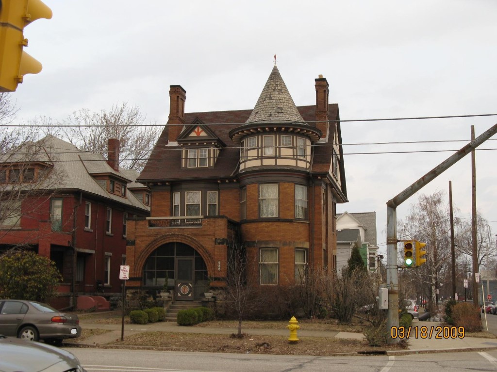
Address: 304 W 10 ST
Parcel: 16030020010000
Parcel Profile
Address
304 | W | 10 | ST
Street Status
PAVED
School District
CITY OF ERIE SCHOOL
Acreage
0.0852
Classification
R
Land Use Code
SINGLE FAMILY
Legal Description
304 W 10 ST 45X82.5
Square Feet
3198
Topo
LEVEL
Utility
ALL PUBLIC
Zoning
Please contact your municipal zoning officer
Deed Book
1012
Deed Page
0253
2026 Tax Values
Land Value / Taxable
8,500 / 8,500.00
Building Value / Taxable
106,000 / 106,000.00
Total Value / Taxable
114,500 / 114,500.00
Clean & Green
Inactive
Homestead Status
Active
Farmstead Status
Inactive
Lerta Amount
0
Lerta Expiration Year
0
Residential Data
Card 1
Style
OLD STYLE
Basement
FULL
Year Built
1903
Exterior Wall
BRICK
Total Living Area
3198
Full Baths
2
Half Baths
1
Fuel Type
GAS
Heating
CENTRAL
Heating System
HOT WATER
Stories
2.0
Total Bedrooms
6
Total Family Rooms
1
Total Rooms
11
Fireplaces
2
Other Buildings & Yards
No OBY Data Found
Sales History
Sale Date
Type
Price
Book / Page
Other Info
5/16/2003
LAND & BUILDING
112000
1012 / 0253
WARRANTY/SURVIVORSHIP DEED
6/30/1999
0
0646 / 1317
Parcel Sketches
Residential Card 1
A
MAIN
1252 square feet
B
UNFIN BSMT BASEMENT UNFINISHED MABAY MASONRY BAY MABAY MASONRY BAY FRBAY FRAME BAY
48 square feet
C
EMP ENCL MASONRY PORCH
172 square feet
D
FRBAY FRAME BAY
20 square feet
E
FRBAY FRAME BAY AT FN ATTIC-FINISHED
9 square feet
F
UNFIN BSMT BASEMENT UNFINISHED OMP OPEN MASONRY PORCH OMP OPEN MASONRY PORCH AT FN ATTIC-FINISHED
42 square feet
G
WDDCK WOOD DECKS
64 square feet
Parcel Images
Please note:
this tab is for informational purposes only and may not show all delinquencies, see the Taxes tab for more accurate delinquent taxes due.