Elected Officials
Courts
Departments
Initiatives
Open Government
About
Login / Register
Home
/
Property & Tax Records
/
Property Records
/
Property & Tax Search
/
Parcel Profile
/
Print View
Search for Another Parcel
Parcel Profile
Historical Card
Sketches
Photos
Tax Map
Taxes
Print View
Print This Page
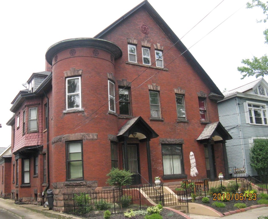
Address: 342 44 W 9 ST
Parcel: 16030020023200
Parcel Profile
Address
342 | 44 | W | 9 | ST
Street Status
PAVED | SIDEWALK
School District
CITY OF ERIE SCHOOL
Acreage
0.1837
Classification
A
Land Use Code
APARTMENTS 4 - 19 UNITS
Legal Description
342 4 W 9 ST 50X160
Square Feet
7453
Topo
LEVEL
Utility
ALL PUBLIC
Zoning
Please contact your municipal zoning officer
Deed Book
2025
Deed Page
007384
2026 Tax Values
Land Value / Taxable
12,000 / 12,000.00
Building Value / Taxable
245,448 / 245,448.00
Total Value / Taxable
257,448 / 257,448.00
Clean & Green
Inactive
Homestead Status
Inactive
Farmstead Status
Inactive
Lerta Amount
0.00
Lerta Expiration Year
2017
Commercial Data
Card 1
APARTMENTS - GARDEN
Business Living Area - 7453
Year Built - 1898
Improvement Name - APARTMENTS
Value - 171120
Other Buildings & Yards
No OBY Data Found
Sales History
Sale Date
Type
Price
Book / Page
Other Info
5/9/2025
LAND & BUILDING
0
2025 / 007384
SPECIAL WARRANTY DEED
7/25/2024
LAND & BUILDING
252000
2024 / 011529
SPECIAL WARRANTY DEED
11/2/2022
LAND & BUILDING
408000
2022 / 023687
DEED
7/30/2007
LAND & BUILDING
103000
1435 / 0257
SPECIAL WARRANTY DEED
10/3/2002
LAND & BUILDING
60000
928 / 1257
6/27/1957
0
0257 / 0206
Parcel Sketches
Commercial Card 1
A
MAIN
1949 square feet
B
MAIN
1947 square feet
C
MAIN
1947 square feet
D
MAIN
974 square feet
E
MAIN
448 square feet
F
MAIN
448 square feet
G
MAIN
448 square feet
H
MAIN
88 square feet
I
MAIN
88 square feet
J
MAIN
21 square feet
K
MAIN
21 square feet
L
MAIN
48 square feet
Parcel Images
Please note:
this tab is for informational purposes only and may not show all delinquencies, see the Taxes tab for more accurate delinquent taxes due.