Elected Officials
Courts
Departments
Initiatives
Open Government
About
Login / Register
Home
/
Property & Tax Records
/
Property Records
/
Property & Tax Search
/
Parcel Profile
/
Print View
Search for Another Parcel
Parcel Profile
Historical Card
Sketches
Photos
Tax Map
Taxes
Print View
Print This Page
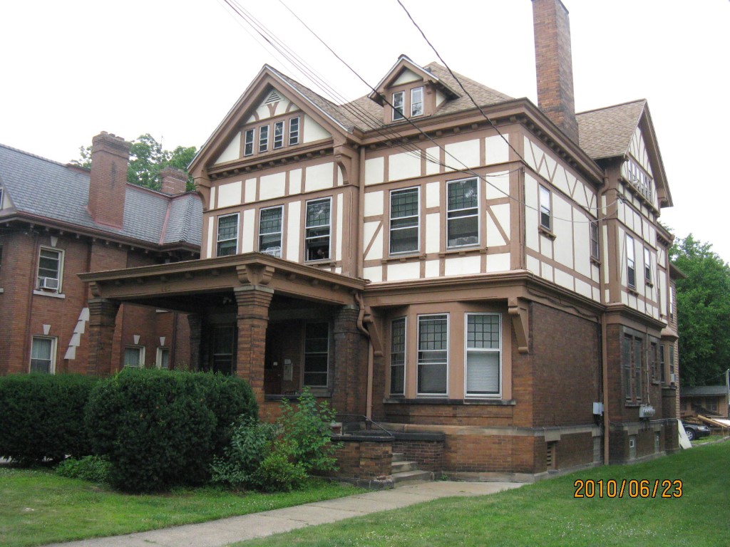
Address: 446 W 10 ST
Parcel: 16030025013400
Parcel Profile
Address
446 | W | 10 | ST
Street Status
PAVED | SIDEWALK
School District
CITY OF ERIE SCHOOL
Acreage
0.2273
Classification
A
Land Use Code
APARTMENTS 4 - 19 UNITS
Legal Description
446 W 10 ST 60 X 165
Square Feet
6541
Topo
LEVEL
Utility
ALL PUBLIC
Zoning
Please contact your municipal zoning officer
Deed Book
2020
Deed Page
023973
2026 Tax Values
Land Value / Taxable
22,300 / 22,300.00
Building Value / Taxable
148,300 / 148,300.00
Total Value / Taxable
170,600 / 170,600.00
Clean & Green
Inactive
Homestead Status
Inactive
Farmstead Status
Inactive
Lerta Amount
0
Lerta Expiration Year
0
Commercial Data
Card 1
RESIDENTIAL 4 FAMILY
Business Living Area - 6541
Year Built - 1905
Improvement Name - APARTMENTS
Value - 144790
Other Buildings & Yards
Description
Built
Width
Length
Area
FRAME OR CB DETACHED GARAGE
1916
0
0
294
PAVING ASPHALT PARKING
1950
0
0
400
Sales History
Sale Date
Type
Price
Book / Page
Other Info
11/9/2020
LAND & BUILDING
490000
2020 / 023973
SPECIAL WARRANTY DEED
5/26/2006
LAND & BUILDING
155000
1331 / 1132
WARRANTY/SURVIVORSHIP DEED
8/5/2005
LAND & BUILDING
145000
1258 / 0827
SPECIAL WARRANTY DEED
12/11/2003
LAND & BUILDING
0
1093 / 1667
QUIT CLAIM DEED
1/24/1984
0
1523 / 0351
Parcel Sketches
Commercial Card 1
A
MAIN
1743 square feet
B
MAIN
1743 square feet
C
MAIN
1743 square feet
D
MAIN
872 square feet
E
MAIN
180 square feet
F
MAIN
180 square feet
G
MAIN
40 square feet
H
MAIN
40 square feet
Parcel Images
Please note:
this tab is for informational purposes only and may not show all delinquencies, see the Taxes tab for more accurate delinquent taxes due.