Elected Officials
Courts
Departments
Initiatives
Open Government
About
Login / Register
Home
/
Property & Tax Records
/
Property Records
/
Property & Tax Search
/
Parcel Profile
/
Print View
Search for Another Parcel
Parcel Profile
Historical Card
Sketches
Photos
Tax Map
Taxes
Print View
Print This Page
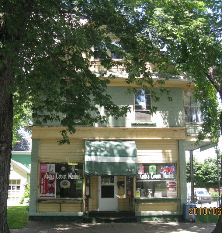
Address: 1102 W 10 ST
Parcel: 16030057010000
Parcel Profile
Address
1102 | W | 10 | ST
Street Status
PAVED
School District
CITY OF ERIE SCHOOL
Acreage
0.0701
Classification
C
Land Use Code
RESTAURANTS, STORES (RETAIL)
Legal Description
1102 W 10 ST 41.25 X 74
Square Feet
3898
Topo
LEVEL
Utility
ALL PUBLIC
Zoning
Please contact your municipal zoning officer
Deed Book
2022
Deed Page
026284
2026 Tax Values
Land Value / Taxable
7,600 / 7,600.00
Building Value / Taxable
58,900 / 58,900.00
Total Value / Taxable
66,500 / 66,500.00
Clean & Green
Inactive
Homestead Status
Inactive
Farmstead Status
Inactive
Lerta Amount
0
Lerta Expiration Year
0
Commercial Data
Card 1
MIXED RESIDENTIAL/COMMERCIAL
Business Living Area - 3898
Year Built - 1900
Improvement Name - KEITH'S CORNER MARKET
Value - 58930
Other Buildings & Yards
No OBY Data Found
Sales History
Sale Date
Type
Price
Book / Page
Other Info
12/16/2022
LAND & BUILDING
0
2022 / 026284
SPECIAL WARRANTY DEED
4/29/2019
LAND & BUILDING
60000
2019 / 007582
SPECIAL WARRANTY DEED
7/22/2002
LAND & BUILDING
51000
902 / 1411
11/2/2000
0
0735 / 2049
Parcel Sketches
Commercial Card 1
A
MAIN
1296 square feet
B
MAIN
1296 square feet
C
MAIN
1306 square feet
D
MAIN
648 square feet
Parcel Images
Please note:
this tab is for informational purposes only and may not show all delinquencies, see the Taxes tab for more accurate delinquent taxes due.