Elected Officials
Courts
Departments
Initiatives
Open Government
About
Login / Register
Home
/
Property & Tax Records
/
Property Records
/
Property & Tax Search
/
Parcel Profile
/
Print View
Search for Another Parcel
Parcel Profile
Historical Card
Sketches
Photos
Tax Map
Taxes
Print View
Print This Page
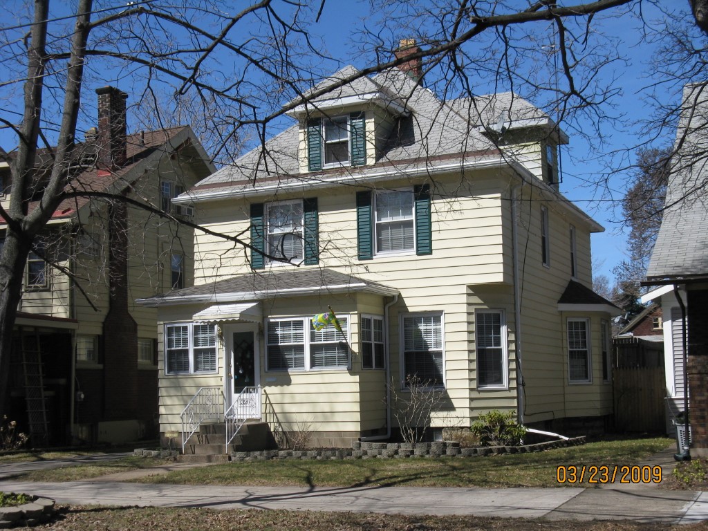
Address: 1320 W 10 ST
Parcel: 16030061014000
Parcel Profile
Address
1320 | W | 10 | ST
Street Status
PAVED
School District
CITY OF ERIE SCHOOL
Acreage
0.1562
Classification
R
Land Use Code
SINGLE FAMILY
Legal Description
1320 W 10 ST 41.25 X 165
Square Feet
1707
Topo
LEVEL
Utility
ALL PUBLIC
Zoning
Please contact your municipal zoning officer
Deed Book
1177
Deed Page
0096
2026 Tax Values
Land Value / Taxable
9,600 / 9,600.00
Building Value / Taxable
83,050 / 83,050.00
Total Value / Taxable
92,650 / 92,650.00
Clean & Green
Inactive
Homestead Status
Active
Farmstead Status
Inactive
Lerta Amount
0
Lerta Expiration Year
0
Residential Data
Card 1
Style
OLD STYLE
Basement
FULL
Year Built
1907
Exterior Wall
ALUMINUM/VINYL
Total Living Area
1707
Full Baths
1
Half Baths
1
Fuel Type
GAS
Heating
CENTRAL
Heating System
HOT WATER
Stories
2.0
Total Bedrooms
4
Total Family Rooms
0
Total Rooms
8
Fireplaces
0
Other Buildings & Yards
Description
Built
Width
Length
Area
FRAME OR CB DETACHED GARAGE
1959
15
23
345
Sales History
Sale Date
Type
Price
Book / Page
Other Info
9/28/2004
LAND & BUILDING
118500
1177 / 0096
WARRANTY/SURVIVORSHIP DEED
9/2/2003
LAND & BUILDING
98000
1058 / 2200
WARRANTY/SURVIVORSHIP DEED
3/30/2000
LAND & BUILDING
56000
695 / 1
Parcel Sketches
Residential Card 1
A
MAIN
803 square feet
B
EFP ENCL FRAME PORCH
42 square feet
C
1S FR ONE STORY FRAME
48 square feet
D
UNFIN BSMT BASEMENT UNFINISHED FRBAY FRAME BAY
24 square feet
E
EFP ENCL FRAME PORCH
96 square feet
F
EFP ENCL FRAME PORCH 1S FR ONE STORY FRAME AT UN ATTIC-UNFINISHED
29 square feet
Parcel Images
Please note:
this tab is for informational purposes only and may not show all delinquencies, see the Taxes tab for more accurate delinquent taxes due.