Elected Officials
Courts
Departments
Initiatives
Open Government
About
Login / Register
Home
/
Property & Tax Records
/
Property Records
/
Property & Tax Search
/
Parcel Profile
/
Print View
Search for Another Parcel
Parcel Profile
Historical Card
Sketches
Photos
Tax Map
Taxes
Print View
Print This Page
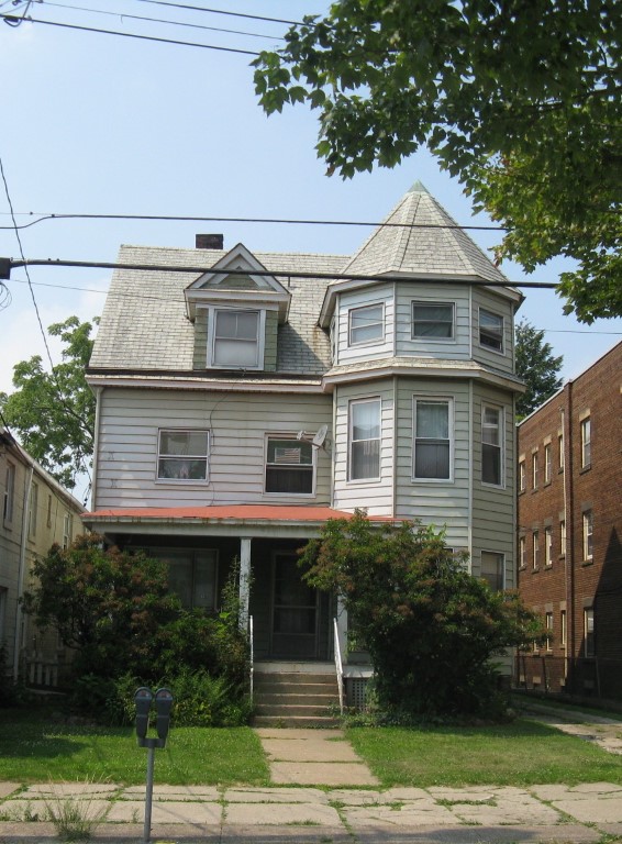
Address: 242 W 8 ST
Parcel: 17040007012800
Parcel Profile
Address
242 | W | 8 | ST
Street Status
PAVED
School District
CITY OF ERIE SCHOOL
Acreage
0.1562
Classification
A
Land Use Code
APARTMENTS 4 - 19 UNITS
Legal Description
242 W 8 ST 41.25X165
Square Feet
4977
Topo
LEVEL
Utility
ALL PUBLIC
Zoning
Please contact your municipal zoning officer
Deed Book
2011
Deed Page
021535
2026 Tax Values
Land Value / Taxable
20,400 / 20,400.00
Building Value / Taxable
80,900 / 80,900.00
Total Value / Taxable
101,300 / 101,300.00
Clean & Green
Inactive
Homestead Status
Inactive
Farmstead Status
Inactive
Lerta Amount
0
Lerta Expiration Year
0
Commercial Data
Card 1
MIXED RESIDENTIAL/COMMERCIAL
Business Living Area - 4977
Year Built - 1877
Improvement Name - APARTMENTS
Value - 83600
Other Buildings & Yards
Description
Built
Width
Length
Area
FRAME OR CB DETACHED GARAGE
1935
20
42
840
PAVING CONCRETE AVERAGE
1960
27
40
1080
Sales History
Sale Date
Type
Price
Book / Page
Other Info
9/12/2011
LAND & BUILDING
0
2011 / 021535
CORRECTIVE DEED
5/27/2011
LAND & BUILDING
101000
2011 / 011976
DEED
2/5/2007
LAND & BUILDING
0
1393 / 1399
QUIT CLAIM DEED
7/1/1998
0
0571 / 1613
Parcel Sketches
Commercial Card 1
A
MAIN
1422 square feet
B
MAIN
1422 square feet
C
MAIN
1422 square feet
D
MAIN
711 square feet
Parcel Images
Please note:
this tab is for informational purposes only and may not show all delinquencies, see the Taxes tab for more accurate delinquent taxes due.