Elected Officials
Courts
Departments
Initiatives
Open Government
About
Login / Register
Home
/
Property & Tax Records
/
Property Records
/
Property & Tax Search
/
Parcel Profile
/
Print View
Search for Another Parcel
Parcel Profile
Historical Card
Sketches
Photos
Tax Map
Taxes
Print View
Print This Page
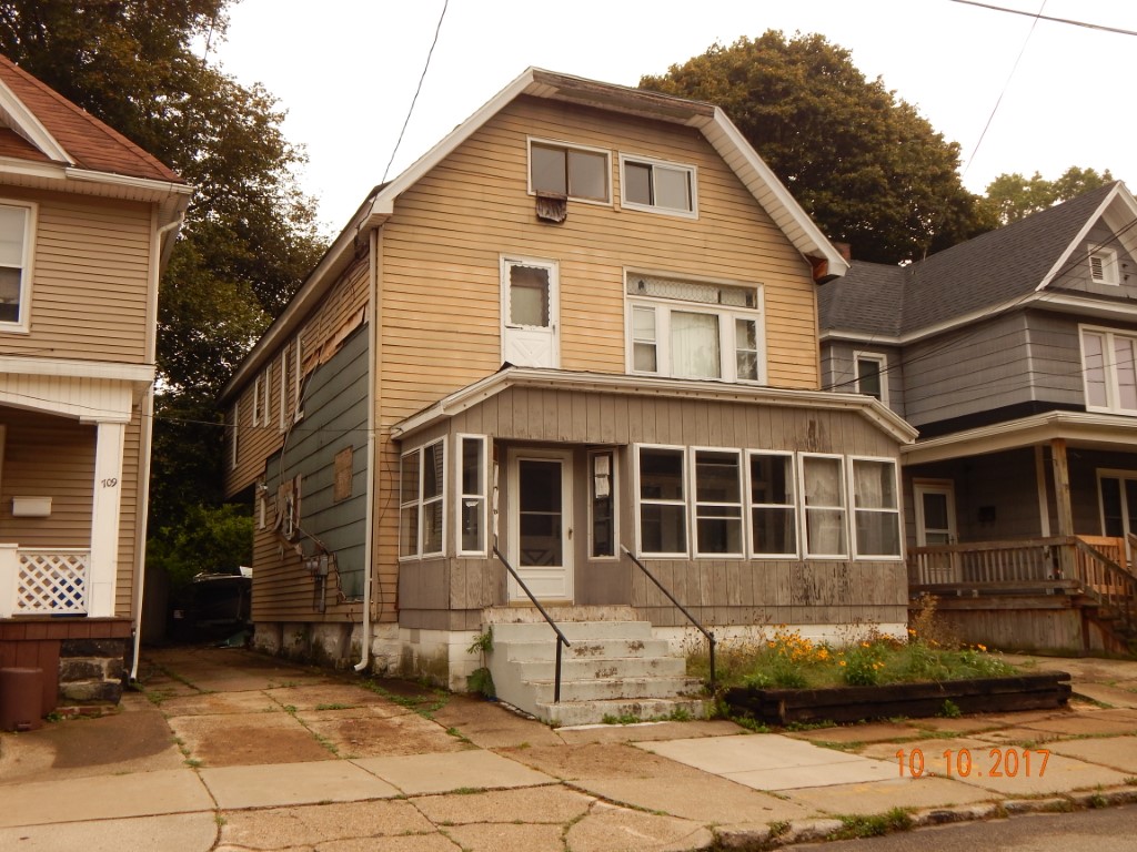
Address: 711 13 RASPBERRY ST
Parcel: 17040031012600
Parcel Profile
Address
711 | 13 | RASPBERRY | ST
Street Status
PAVED | SIDEWALK
School District
CITY OF ERIE SCHOOL
Acreage
0.0661
Classification
R
Land Use Code
TWO FAMILY
Legal Description
711 13 RASPBERRY ST 30 X 96
Square Feet
2698
Topo
LEVEL
Utility
ALL PUBLIC
Zoning
Please contact your municipal zoning officer
Deed Book
2022
Deed Page
008396
2026 Tax Values
Land Value / Taxable
7,300 / 7,300.00
Building Value / Taxable
17,700 / 17,700.00
Total Value / Taxable
25,000 / 25,000.00
Clean & Green
Inactive
Homestead Status
Inactive
Farmstead Status
Inactive
Lerta Amount
0
Lerta Expiration Year
0
Residential Data
Card 1
Style
OLD STYLE
Basement
FULL
Year Built
1929
Exterior Wall
ALUMINUM/VINYL
Total Living Area
2698
Full Baths
2
Half Baths
0
Fuel Type
GAS
Heating
NONE
Heating System
FORCED AIR
Stories
2.0
Total Bedrooms
6
Total Family Rooms
0
Total Rooms
12
Fireplaces
0
Other Buildings & Yards
Description
Built
Width
Length
Area
FRAME UTILITY SHED
1997
12
20
240
Sales History
Sale Date
Type
Price
Book / Page
Other Info
4/20/2022
LAND & BUILDING
28000
2022 / 008396
SPECIAL WARRANTY DEED
8/31/2016
LAND & BUILDING
25007
2016 / 018842
SPECIAL WARRANTY DEED
4/11/2016
LAND & BUILDING
12403
2016 / 006981
SHERIFF'S DED
3/5/2009
LAND & BUILDING
0
1546 / 2094
DEED
8/21/2002
LAND & BUILDING
60000
912 / 1427
8/10/1977
0
1275 / 0355
Parcel Sketches
Residential Card 1
A
MAIN
1104 square feet
B
FROVR FRAME OVERHANG
48 square feet
C
EFP ENCL FRAME PORCH
72 square feet
D
OFP OPEN FRAME PORCH
132 square feet
Parcel Images
Please note:
this tab is for informational purposes only and may not show all delinquencies, see the Taxes tab for more accurate delinquent taxes due.