Elected Officials
Courts
Departments
Initiatives
Open Government
About
Login / Register
Home
/
Property & Tax Records
/
Property Records
/
Property & Tax Search
/
Parcel Profile
/
Print View
Search for Another Parcel
Parcel Profile
Historical Card
Sketches
Photos
Tax Map
Taxes
Print View
Print This Page
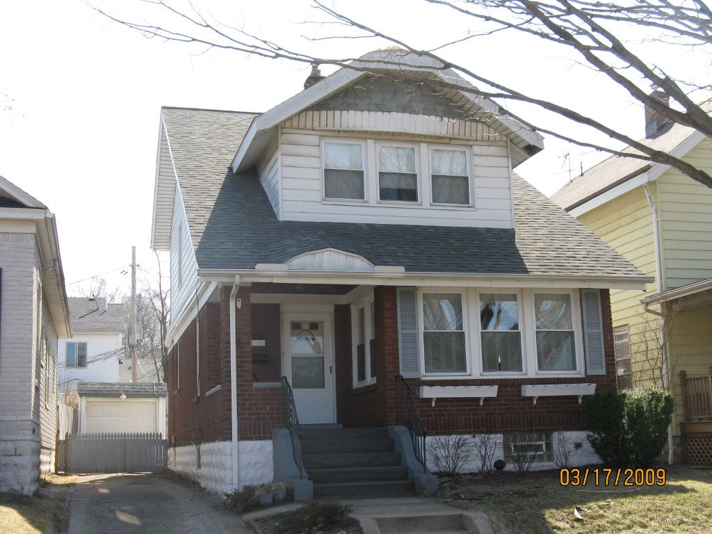
Address: 1921 OXFORD ST
Parcel: 17041023050600
Parcel Profile
Address
1921 | OXFORD | ST
Street Status
PAVED
School District
CITY OF ERIE SCHOOL
Acreage
0.0735
Classification
R
Land Use Code
SINGLE FAMILY
Legal Description
1921 OXFORD ST 32X100
Square Feet
1449
Topo
LEVEL
Utility
ALL PUBLIC
Zoning
Please contact your municipal zoning officer
Deed Book
0028
Deed Page
1848
2026 Tax Values
Land Value / Taxable
32,700 / 32,700.00
Building Value / Taxable
81,900 / 81,900.00
Total Value / Taxable
114,600 / 114,600.00
Clean & Green
Inactive
Homestead Status
Active
Farmstead Status
Inactive
Lerta Amount
0
Lerta Expiration Year
0
Residential Data
Card 1
Style
OLD STYLE
Basement
FULL
Year Built
1930
Exterior Wall
MASONRY & FRAME
Total Living Area
1449
Full Baths
1
Half Baths
0
Fuel Type
GAS
Heating
CENTRAL A/C
Heating System
FORCED AIR
Stories
2.0
Total Bedrooms
3
Total Family Rooms
0
Total Rooms
6
Fireplaces
0
Other Buildings & Yards
Description
Built
Width
Length
Area
FRAME OR CB DETACHED GARAGE
1930
9
18
162
Sales History
Sale Date
Type
Price
Book / Page
Other Info
9/28/1987
0
0028 / 1848
Parcel Sketches
Residential Card 1
A
MAIN
528 square feet
B
UNFIN BSMT BASEMENT UNFINISHED 1SMAS MASONRY AT FN ATTIC-FINISHED
132 square feet
C
UNFIN BSMT BASEMENT UNFINISHED 1SMAS MASONRY 1S FR ONE STORY FRAME
40 square feet
D
UNFIN BSMT BASEMENT UNFINISHED 1SMAS MASONRY
112 square feet
E
OMP OPEN MASONRY PORCH 1S FR ONE STORY FRAME
16 square feet
F
OMP OPEN MASONRY PORCH
64 square feet
G
WDDCK WOOD DECKS
220 square feet
Parcel Images
Please note:
this tab is for informational purposes only and may not show all delinquencies, see the Taxes tab for more accurate delinquent taxes due.