Elected Officials
Courts
Departments
Initiatives
Open Government
About
Login / Register
Home
/
Property & Tax Records
/
Property Records
/
Property & Tax Search
/
Parcel Profile
/
Print View
Search for Another Parcel
Parcel Profile
Historical Card
Sketches
Photos
Tax Map
Taxes
Print View
Print This Page
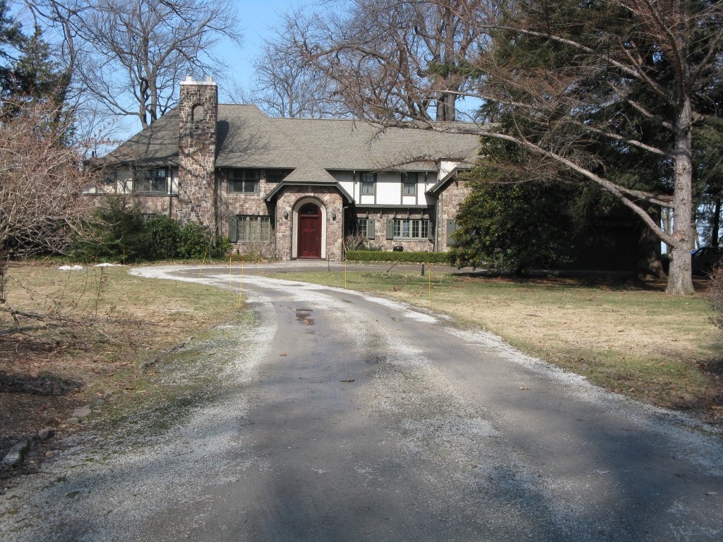
Address: 2050 S SHORE DR
Parcel: 17041034010100
Parcel Profile
Address
2050 | S | SHORE | DR
Street Status
PAVED
School District
CITY OF ERIE SCHOOL
Acreage
1.8101
Classification
R
Land Use Code
SINGLE FAMILY
Legal Description
2050 S SHORE DR 237.60 X IRR
Square Feet
6740
Topo
LEVEL
Utility
ALL PUBLIC
Zoning
Please contact your municipal zoning officer
Deed Book
0487
Deed Page
0750
2026 Tax Values
Land Value / Taxable
248,600 / 248,600.00
Building Value / Taxable
692,250 / 692,250.00
Total Value / Taxable
940,850 / 940,850.00
Clean & Green
Inactive
Homestead Status
Active
Farmstead Status
Inactive
Lerta Amount
0
Lerta Expiration Year
0
Residential Data
Card 1
Style
TUDOR
Basement
FULL
Year Built
1921
Exterior Wall
STONE
Total Living Area
6740
Full Baths
3
Half Baths
0
Fuel Type
GAS
Heating
CENTRAL A/C
Heating System
HOT WATER
Stories
2.0
Total Bedrooms
6
Total Family Rooms
0
Total Rooms
12
Fireplaces
3
Other Buildings & Yards
No OBY Data Found
Sales History
Sale Date
Type
Price
Book / Page
Other Info
3/12/1997
0
0487 / 0750
Parcel Sketches
Residential Card 1
A
MAIN
1777 square feet
B
1SMAS MASONRY
306 square feet
C
MABAY MASONRY BAY
24 square feet
D
UNFIN BSMT BASEMENT UNFINISHED 1SMAS MASONRY 1SMAS MASONRY AT FN ATTIC-FINISHED
520 square feet
E
1SMAS MASONRY
169 square feet
F
MG/BG MASONRY/BRICK GARAGE
169 square feet
G
MG/BG MASONRY/BRICK GARAGE 1SMAS MASONRY AT FN ATTIC-FINISHED
520 square feet
H
EMP ENCL MASONRY PORCH
60 square feet
I
MA STOOP/TERR MAS STOOP
30 square feet
Parcel Images
Please note:
this tab is for informational purposes only and may not show all delinquencies, see the Taxes tab for more accurate delinquent taxes due.