Elected Officials
Courts
Departments
Initiatives
Open Government
About
Login / Register
Home
/
Property & Tax Records
/
Property Records
/
Property & Tax Search
/
Parcel Profile
/
Print View
Search for Another Parcel
Parcel Profile
Historical Card
Sketches
Photos
Tax Map
Taxes
Print View
Print This Page
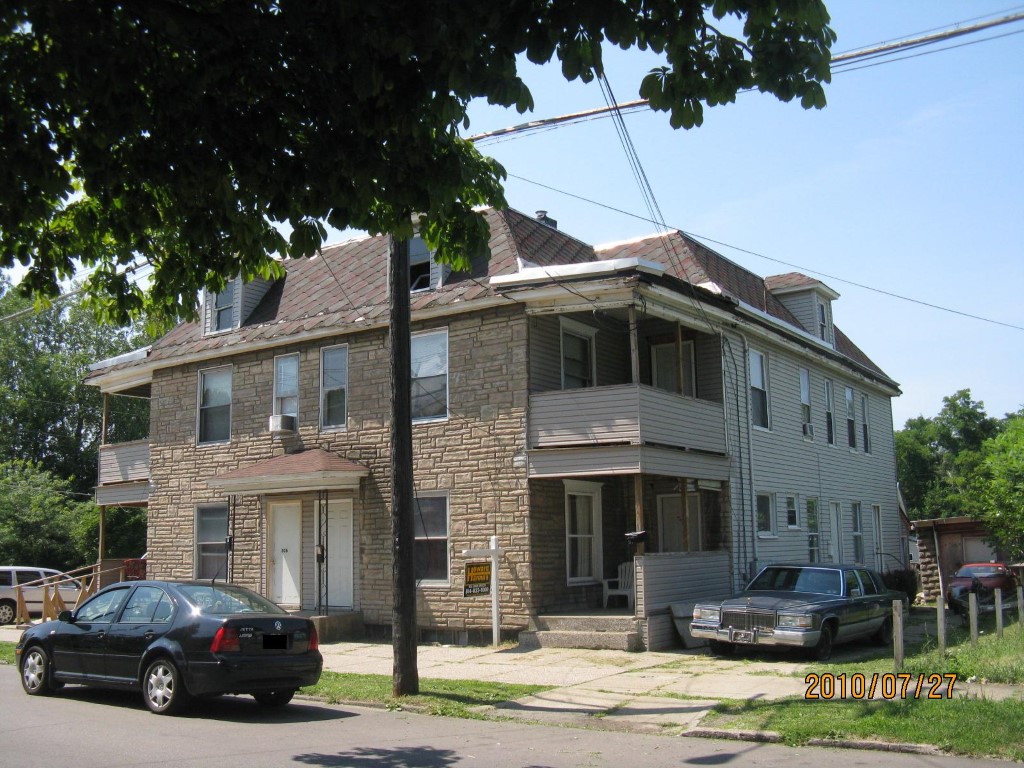
Address: 806 10 E 21 ST
Parcel: 18050033023600
Parcel Profile
Address
806 | 10 | E | 21 | ST
Street Status
PAVED | SIDEWALK
School District
CITY OF ERIE SCHOOL
Acreage
0.1156
Classification
A
Land Use Code
APARTMENTS 4 - 19 UNITS
Legal Description
806 08 10 E 21 ST 65.6 X IRR
Square Feet
7272
Topo
LEVEL
Utility
ALL PUBLIC
Zoning
Please contact your municipal zoning officer
Deed Book
2022
Deed Page
018441
2026 Tax Values
Land Value / Taxable
12,000 / 12,000.00
Building Value / Taxable
17,500 / 17,500.00
Total Value / Taxable
29,500 / 29,500.00
Clean & Green
Inactive
Homestead Status
Inactive
Farmstead Status
Inactive
Lerta Amount
0
Lerta Expiration Year
0
Commercial Data
Card 1
MIXED RESIDENTIAL/COMMERCIAL
Business Living Area - 7272
Year Built - 1904
Improvement Name - APARTMENTS
Value - 62290
Other Buildings & Yards
Description
Built
Width
Length
Area
FRAME OR CB DETACHED GARAGE
1920
12
15
180
Sales History
Sale Date
Type
Price
Book / Page
Other Info
8/23/2022
LAND & BUILDING
0
2022 / 018441
QUIT CLAIM DEED
11/5/2021
LAND & BUILDING
125000
2021 / 029758
DEED
4/24/2018
LAND & BUILDING
120000
2018 / 007623
WARRANTY/SURVIVORSHIP DEED
7/25/2016
LAND & BUILDING
31000
2016 / 015603
SPECIAL WARRANTY DEED
7/6/2016
LAND & BUILDING
0
2016 / 014163
QUIT CLAIM DEED
12/10/2002
LAND & BUILDING
32000
955 / 71
10/23/1997
0
0525 / 0786
Parcel Sketches
Commercial Card 1
A
MAIN
2424 square feet
B
MAIN
2424 square feet
C
MAIN
2424 square feet
D
MAIN
1212 square feet
Parcel Images
Please note:
this tab is for informational purposes only and may not show all delinquencies, see the Taxes tab for more accurate delinquent taxes due.