Elected Officials
Courts
Departments
Initiatives
Open Government
About
Login / Register
Home
/
Property & Tax Records
/
Property Records
/
Property & Tax Search
/
Parcel Profile
/
Print View
Search for Another Parcel
Parcel Profile
Historical Card
Sketches
Photos
Tax Map
Taxes
Print View
Print This Page
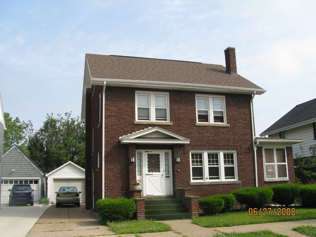
Address: 112 W 33 ST
Parcel: 18053035031600
Parcel Profile
Address
112 | W | 33 | ST
Street Status
PAVED | SIDEWALK
School District
CITY OF ERIE SCHOOL
Acreage
0.1148
Classification
R
Land Use Code
SINGLE FAMILY
Legal Description
112 W 33 ST 50X100
Square Feet
1747
Topo
LEVEL
Utility
ALL PUBLIC
Zoning
Please contact your municipal zoning officer
Deed Book
2020
Deed Page
023485
2026 Tax Values
Land Value / Taxable
17,400 / 17,400.00
Building Value / Taxable
92,300 / 92,300.00
Total Value / Taxable
109,700 / 109,700.00
Clean & Green
Inactive
Homestead Status
Active
Farmstead Status
Inactive
Lerta Amount
0
Lerta Expiration Year
0
Residential Data
Card 1
Style
OLD STYLE
Basement
FULL
Year Built
1923
Exterior Wall
BRICK
Total Living Area
1747
Full Baths
1
Half Baths
0
Fuel Type
GAS
Heating
CENTRAL
Heating System
HOT WATER
Stories
2.0
Total Bedrooms
3
Total Family Rooms
0
Total Rooms
7
Fireplaces
1
Other Buildings & Yards
Description
Built
Width
Length
Area
FRAME OR CB DETACHED GARAGE
1923
12
18
216
Sales History
Sale Date
Type
Price
Book / Page
Other Info
11/4/2020
LAND & BUILDING
119500
2020 / 023485
SPECIAL WARRANTY DEED
1/18/2008
LAND & BUILDING
119000
1472 / 0343
WARRANTY/SURVIVORSHIP DEED
7/25/2003
LAND & BUILDING
118000
1041 / 0034
WARRANTY/SURVIVORSHIP DEED
10/16/1992
0
0235 / 0821
Parcel Sketches
Residential Card 1
A
MAIN
728 square feet
B
EMP ENCL MASONRY PORCH
144 square feet
C
MA STOOP/TERR MAS STOOP
32 square feet
Parcel Images
Please note:
this tab is for informational purposes only and may not show all delinquencies, see the Taxes tab for more accurate delinquent taxes due.