Elected Officials
Courts
Departments
Initiatives
Open Government
About
Login / Register
Home
/
Property & Tax Records
/
Property Records
/
Property & Tax Search
/
Parcel Profile
/
Print View
Search for Another Parcel
Parcel Profile
Historical Card
Sketches
Photos
Tax Map
Taxes
Print View
Print This Page
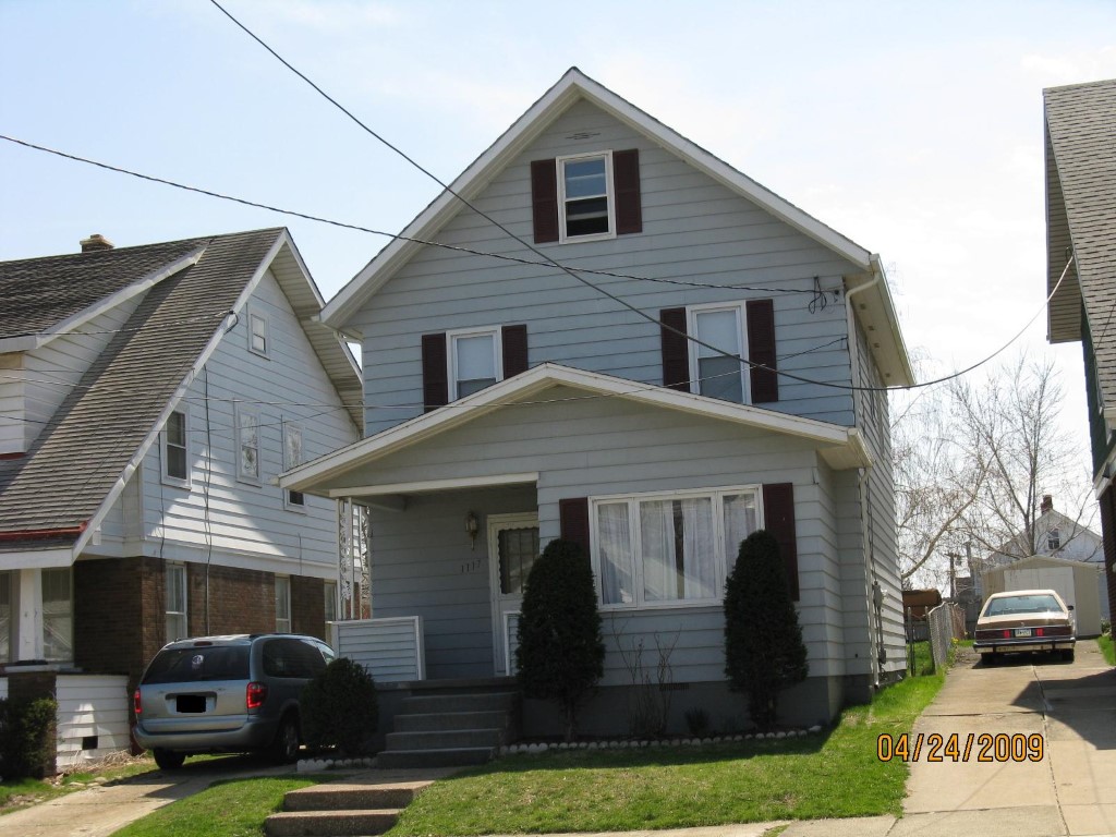
Address: 1117 W 25 ST
Parcel: 19060036010900
Parcel Profile
Address
1117 | W | 25 | ST
Street Status
PAVED | SIDEWALK
School District
CITY OF ERIE SCHOOL
Acreage
0.1171
Classification
R
Land Use Code
SINGLE FAMILY
Legal Description
1117 W 25 ST 34X150
Square Feet
1408
Topo
LEVEL
Utility
ALL PUBLIC
Zoning
Please contact your municipal zoning officer
Deed Book
2011
Deed Page
006353
2026 Tax Values
Land Value / Taxable
11,100 / 11,100.00
Building Value / Taxable
65,550 / 65,550.00
Total Value / Taxable
76,650 / 76,650.00
Clean & Green
Inactive
Homestead Status
Active
Farmstead Status
Inactive
Lerta Amount
0
Lerta Expiration Year
0
Residential Data
Card 1
Style
OLD STYLE
Basement
FULL
Year Built
1919
Exterior Wall
ALUMINUM/VINYL
Total Living Area
1408
Full Baths
1
Half Baths
0
Fuel Type
GAS
Heating
CENTRAL
Heating System
FORCED AIR
Stories
2.0
Total Bedrooms
4
Total Family Rooms
0
Total Rooms
7
Fireplaces
0
Other Buildings & Yards
Description
Built
Width
Length
Area
FRAME OR CB DETACHED GARAGE
1976
12
18
216
Sales History
Sale Date
Type
Price
Book / Page
Other Info
3/18/2011
LAND & BUILDING
49500
2011 / 006353
SPECIAL WARRANTY DEED
11/18/2010
LAND & BUILDING
0
2010 / 028986
SHERIFF'S DED
12/15/2005
LAND & BUILDING
84900
1294 / 0699
SPECIAL WARRANTY DEED
6/30/2003
LAND & BUILDING
71500
1029 / 1943
WARRANTY/SURVIVORSHIP DEED
10/23/1992
0
0236 / 1636
Parcel Sketches
Residential Card 1
A
MAIN
660 square feet
B
OFP OPEN FRAME PORCH
128 square feet
C
1S FR ONE STORY FRAME
88 square feet
D
OFP OPEN FRAME PORCH
72 square feet
Parcel Images
Please note:
this tab is for informational purposes only and may not show all delinquencies, see the Taxes tab for more accurate delinquent taxes due.