Elected Officials
Courts
Departments
Initiatives
Open Government
About
Login / Register
Home
/
Property & Tax Records
/
Property Records
/
Property & Tax Search
/
Parcel Profile
/
Print View
Search for Another Parcel
Parcel Profile
Historical Card
Sketches
Photos
Tax Map
Taxes
Print View
Print This Page
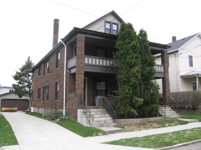
Address: 2918 20 CHESTNUT ST
Parcel: 19060049030100
Parcel Profile
Address
2918 | 20 | CHESTNUT | ST
Street Status
PAVED
School District
CITY OF ERIE SCHOOL
Acreage
0.1584
Classification
R
Land Use Code
TWO FAMILY
Legal Description
2918 20 CHESTNUT ST 52.5X120
Square Feet
2688
Topo
LEVEL
Utility
ALL PUBLIC
Zoning
Please contact your municipal zoning officer
Deed Book
0944
Deed Page
2006
2026 Tax Values
Land Value / Taxable
11,600 / 11,600.00
Building Value / Taxable
77,850 / 77,850.00
Total Value / Taxable
89,450 / 89,450.00
Clean & Green
Inactive
Homestead Status
Active
Farmstead Status
Inactive
Lerta Amount
0
Lerta Expiration Year
0
Residential Data
Card 1
Style
OLD STYLE
Basement
FULL
Year Built
1923
Exterior Wall
BRICK
Total Living Area
2688
Full Baths
2
Half Baths
0
Fuel Type
GAS
Heating
CENTRAL
Heating System
FORCED AIR
Stories
2.0
Total Bedrooms
6
Total Family Rooms
0
Total Rooms
12
Fireplaces
0
Other Buildings & Yards
Description
Built
Width
Length
Area
FRAME OR CB DETACHED GARAGE
2001
24
24
576
Sales History
Sale Date
Type
Price
Book / Page
Other Info
11/14/2002
LAND & BUILDING
40000
0944 / 2006
10/25/2002
LAND & BUILDING
0
937 / 842
AFFIDAVIT
3/5/1985
0
1571 / 0001
Parcel Sketches
Residential Card 1
A
MAIN
1344 square feet
B
UNFIN BSMT BASEMENT UNFINISHED EMP ENCL MASONRY PORCH OFP OPEN FRAME PORCH
16 square feet
C
EFP ENCL FRAME PORCH EFP ENCL FRAME PORCH
84 square feet
D
UNFIN BSMT BASEMENT UNFINISHED OMP OPEN MASONRY PORCH OFP OPEN FRAME PORCH
208 square feet
Parcel Images
Please note:
this tab is for informational purposes only and may not show all delinquencies, see the Taxes tab for more accurate delinquent taxes due.