Elected Officials
Courts
Departments
Initiatives
Open Government
About
Login / Register
Home
/
Property & Tax Records
/
Property Records
/
Property & Tax Search
/
Parcel Profile
/
Print View
Search for Another Parcel
Parcel Profile
Historical Card
Sketches
Photos
Tax Map
Taxes
Print View
Print This Page
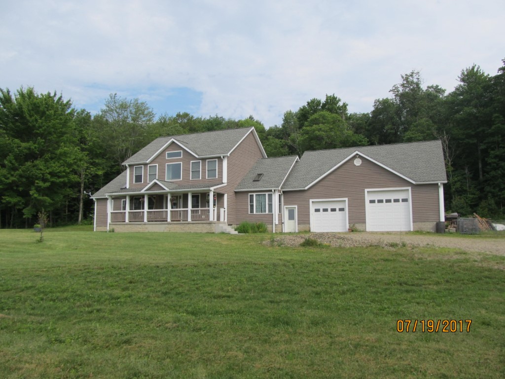
Address: 10474 SAMPSON RD
Parcel: 25023060000801
Parcel Profile
Address
10474 | SAMPSON | RD
Street Status
SEMI IMPROVED
School District
WATTSBURG SCHOOL
Acreage
3.9790
Classification
R
Land Use Code
SINGLE FAMILY
Legal Description
10474 SAMPSON RD LOT B 3.979 AC
Square Feet
3008
Topo
ROLLING
Utility
WELL | SEPTIC
Zoning
Please contact your municipal zoning officer
Deed Book
2026
Deed Page
011199
2026 Tax Values
Land Value / Taxable
46,700 / 46,700.00
Building Value / Taxable
270,550 / 270,550.00
Total Value / Taxable
317,250 / 317,250.00
Clean & Green
Inactive
Homestead Status
Active
Farmstead Status
Inactive
Lerta Amount
0
Lerta Expiration Year
0
Residential Data
Card 1
Style
CONVENTIONAL
Basement
FULL
Year Built
2006
Exterior Wall
ALUMINUM/VINYL
Total Living Area
3008
Full Baths
2
Half Baths
1
Fuel Type
PROPANE
Heating
CENTRAL
Heating System
FORCED AIR
Stories
2.0
Total Bedrooms
3
Total Family Rooms
0
Total Rooms
8
Fireplaces
1
Other Buildings & Yards
No OBY Data Found
Sales History
Sale Date
Type
Price
Book / Page
Other Info
6/26/2026
LAND & BUILDING
525000
2026 / 011199
SPECIAL WARRANTY DEED
10/19/2012
LAND & BUILDING
239500
2012 / 028890
DEED
7/28/2011
LAND & BUILDING
0
2011 / 017316
SHERIFF'S DED
3/24/2006
LAND
0
1314 / 2177
WARRANTY/SURVIVORSHIP DEED
Parcel Sketches
Residential Card 1
A
MAIN
1024 square feet
B
UNFIN BSMT BASEMENT UNFINISHED 1S FR ONE STORY FRAME
576 square feet
C
UNFIN BSMT BASEMENT UNFINISHED 1S FR ONE STORY FRAME
384 square feet
D
FR GR FRAME GARAGE
1600 square feet
E
OFP OPEN FRAME PORCH
224 square feet
Parcel Images
Please note:
this tab is for informational purposes only and may not show all delinquencies, see the Taxes tab for more accurate delinquent taxes due.