Elected Officials
Courts
Departments
Initiatives
Open Government
About
Login / Register
Home
/
Property & Tax Records
/
Property Records
/
Property & Tax Search
/
Parcel Profile
/
Print View
Search for Another Parcel
Parcel Profile
Historical Card
Sketches
Photos
Tax Map
Taxes
Print View
Print This Page
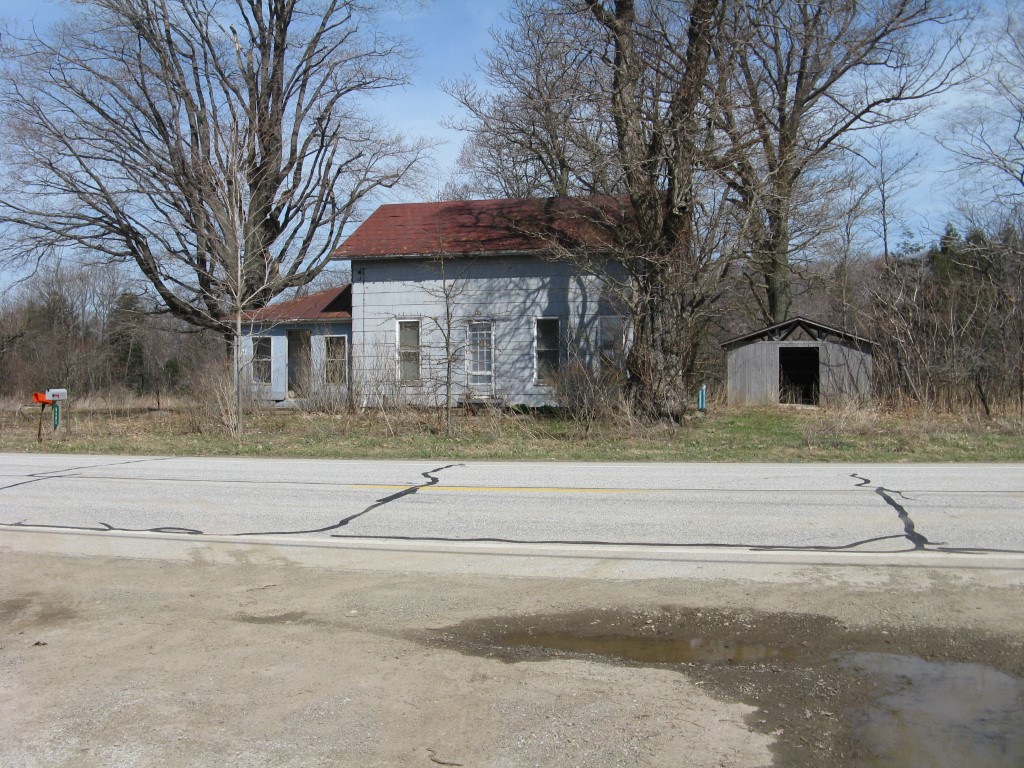
Address: 6566 WEST RD
Parcel: 31011022002000
Parcel Profile
Address
6566 | WEST | RD
Street Status
PAVED
School District
GENERAL MCLANE SCHOOL
Acreage
46.6100
Classification
E
Land Use Code
EXEMPT NON-PROFIT ORGANIZATIONS
Legal Description
6566 WEST RD 46.61 AC CAL
Square Feet
1400
Topo
LEVEL
Utility
SEPTIC
Zoning
Please contact your municipal zoning officer
Deed Book
1546
Deed Page
1560
2026 Tax Values
Land Value / Taxable
95,100 / 95,100.00
Building Value / Taxable
18,700 / 18,700.00
Total Value / Taxable
113,800 / 113,800.00
Clean & Green
Inactive
Homestead Status
Inactive
Farmstead Status
Inactive
Lerta Amount
0
Lerta Expiration Year
0
Residential Data
Card 1
Style
OLD STYLE
Basement
CRAWL
Year Built
1847
Exterior Wall
COMPOSITION
Total Living Area
1400
Full Baths
1
Half Baths
0
Fuel Type
COAL/WOOD
Heating
CENTRAL
Heating System
HOT WATER
Stories
1.5
Total Bedrooms
4
Total Family Rooms
0
Total Rooms
7
Fireplaces
0
Other Buildings & Yards
No OBY Data Found
Sales History
Sale Date
Type
Price
Book / Page
Other Info
3/3/2009
LAND & BUILDING
0
1546 / 1560
CORRECTIVE DEED
12/11/2008
LAND & BUILDING
250000
1535 / 0354
DEED
4/28/1978
0
1303 / 0031
Parcel Sketches
Residential Card 1
A
MAIN
672 square feet
B
EFP ENCL FRAME PORCH
70 square feet
C
1S FR ONE STORY FRAME
224 square feet
D
FR UT FRAME UTILITY BUILDING
288 square feet
Parcel Images
Please note:
this tab is for informational purposes only and may not show all delinquencies, see the Taxes tab for more accurate delinquent taxes due.