Elected Officials
Courts
Departments
Initiatives
Open Government
About
Login / Register
Home
/
Property & Tax Records
/
Property Records
/
Property & Tax Search
/
Parcel Profile
/
Print View
Search for Another Parcel
Parcel Profile
Historical Card
Sketches
Photos
Tax Map
Taxes
Print View
Print This Page
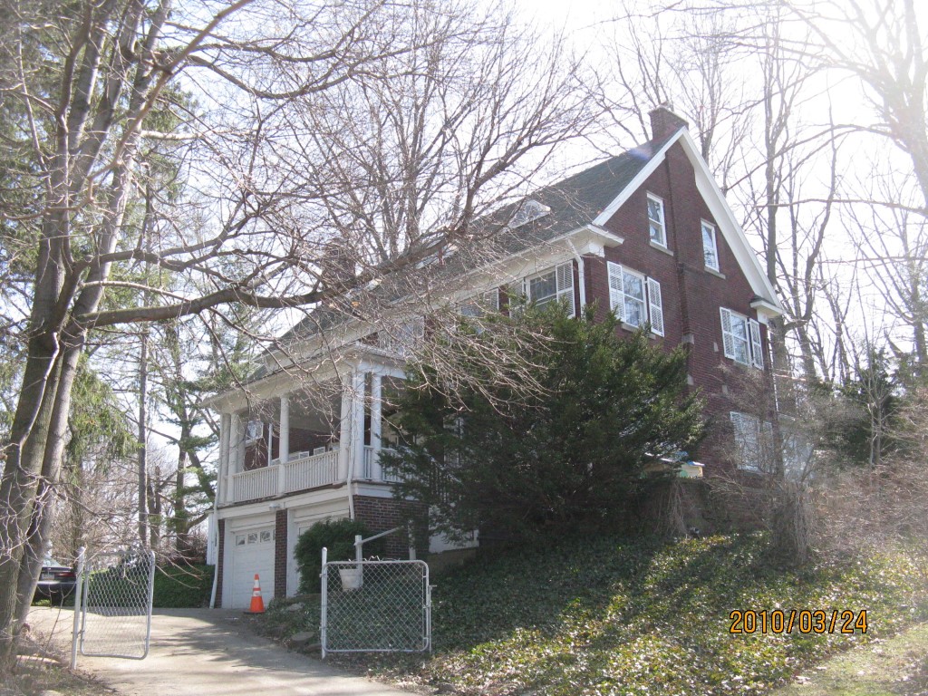
Address: 1215 CHESTNUT HILL DR
Parcel: 33100441000101
Parcel Profile
Address
1215 | CHESTNUT HILL | DR
Street Status
PAVED
School District
MILLCREEK SCHOOL
Acreage
0.5876
Classification
R
Land Use Code
SINGLE FAMILY
Legal Description
1215 CHESTNUT HILL DR 195X141.9IR
Square Feet
3477
Topo
LEVEL
Utility
ALL PUBLIC
Zoning
Please contact your municipal zoning officer
Deed Book
2020
Deed Page
007584
2026 Tax Values
Land Value / Taxable
23,500 / 23,500.00
Building Value / Taxable
244,130 / 244,130.00
Total Value / Taxable
267,630 / 267,630.00
Clean & Green
Inactive
Homestead Status
Active
Farmstead Status
Inactive
Lerta Amount
0
Lerta Expiration Year
0
Residential Data
Card 1
Style
OLD STYLE
Basement
FULL
Year Built
1900
Exterior Wall
BRICK
Total Living Area
3477
Full Baths
2
Half Baths
2
Fuel Type
GAS
Heating
CENTRAL
Heating System
FORCED AIR
Stories
2.0
Total Bedrooms
6
Total Family Rooms
0
Total Rooms
11
Fireplaces
3
Other Buildings & Yards
No OBY Data Found
Sales History
Sale Date
Type
Price
Book / Page
Other Info
4/30/2020
LAND & BUILDING
255000
2020 / 007584
SPECIAL WARRANTY DEED
5/23/2003
LAND & BUILDING
245000
1015 / 1061
DEED
7/31/2000
LAND & BUILDING
225000
718 / 36
Parcel Sketches
Residential Card 1
A
MAIN
1032 square feet
B
EFP ENCL FRAME PORCH
30 square feet
C
1SMAS MASONRY 1SMAS MASONRY AT UN ATTIC-UNFINISHED
360 square feet
D
OFP OPEN FRAME PORCH
40 square feet
E
FR UT FRAME UTILITY BUILDING
48 square feet
F
1SMAS MASONRY
280 square feet
G
MG/BG MASONRY/BRICK GARAGE OFP OPEN FRAME PORCH
360 square feet
Parcel Images
Please note:
this tab is for informational purposes only and may not show all delinquencies, see the Taxes tab for more accurate delinquent taxes due.