Elected Officials
Courts
Departments
Initiatives
Open Government
About
Login / Register
Home
/
Property & Tax Records
/
Property Records
/
Property & Tax Search
/
Parcel Profile
/
Print View
Search for Another Parcel
Parcel Profile
Historical Card
Sketches
Photos
Tax Map
Taxes
Print View
Print This Page
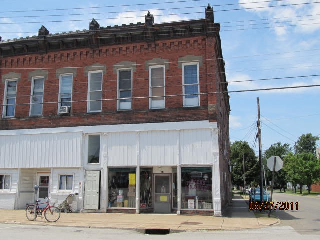
Address: 71 S PEARL ST
Parcel: 35007048000200
Parcel Profile
Address
71 | S | PEARL | ST
Street Status
PAVED
School District
NORTH EAST SCHOOL
Acreage
0.0465
Classification
C
Land Use Code
RESTAURANTS, STORES (RETAIL)
Legal Description
71 S PEARL ST 22.5X90
Square Feet
3080
Topo
LEVEL
Utility
ALL PUBLIC
Zoning
Please contact your municipal zoning officer
Deed Book
2019
Deed Page
012713
2026 Tax Values
Land Value / Taxable
5,100 / 5,100.00
Building Value / Taxable
67,400 / 67,400.00
Total Value / Taxable
72,500 / 72,500.00
Clean & Green
Inactive
Homestead Status
Inactive
Farmstead Status
Inactive
Lerta Amount
0
Lerta Expiration Year
0
Commercial Data
Card 1
RETAIL MULTI OCCUP
Business Living Area - 3080
Year Built - 1900
Improvement Name - RETAIL RENTAL
Value - 67410
Other Buildings & Yards
No OBY Data Found
Sales History
Sale Date
Type
Price
Book / Page
Other Info
7/2/2019
LAND & BUILDING
139900
2019 / 012713
SPECIAL WARRANTY DEED
9/23/1985
0
1598 / 0388
Parcel Sketches
Commercial Card 1
A
MAIN
1540 square feet
B
MAIN
1540 square feet
C
MAIN
1540 square feet
Parcel Images
Please note:
this tab is for informational purposes only and may not show all delinquencies, see the Taxes tab for more accurate delinquent taxes due.