Elected Officials
Courts
Departments
Initiatives
Open Government
About
Login / Register
Home
/
Property & Tax Records
/
Property Records
/
Property & Tax Search
/
Parcel Profile
/
Print View
Search for Another Parcel
Parcel Profile
Historical Card
Sketches
Photos
Tax Map
Taxes
Print View
Print This Page
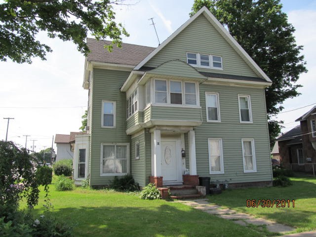
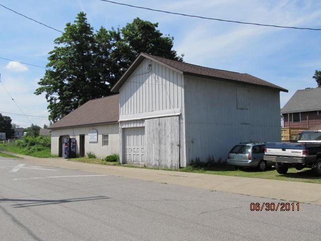
Address: 53 CLAY ST
Parcel: 36010041000800
Parcel Profile
Address
53 | CLAY | ST
Street Status
PAVED
School District
NORTH EAST SCHOOL
Acreage
0.3487
Classification
C
Land Use Code
WAREHOUSES
Legal Description
53 CLAY ST 70 X 217
Square Feet
7774
Topo
LEVEL
Utility
ALL PUBLIC
Zoning
Please contact your municipal zoning officer
Deed Book
1208
Deed Page
0581
2026 Tax Values
Land Value / Taxable
27,300 / 27,300.00
Building Value / Taxable
82,700 / 82,700.00
Total Value / Taxable
110,000 / 110,000.00
Clean & Green
Inactive
Homestead Status
Active
Farmstead Status
Inactive
Lerta Amount
0
Lerta Expiration Year
0
Commercial Data
Card 1
WAREHOUSE
Business Living Area - 2220
Year Built - 1920
Improvement Name - SNYDER COUNTERTOP
Value - 21740
Card 2
MIXED RESIDENTIAL/COMMERCIAL
Business Living Area - 5554
Year Built - 1920
Improvement Name - HOUSE
Value - 65810
Other Buildings & Yards
Description
Built
Width
Length
Area
FRAME UTILITY SHED
1920
14
15
210
Sales History
Sale Date
Type
Price
Book / Page
Other Info
2/1/2005
LAND & BUILDING
0
1208 / 0581
QUIT CLAIM DEED
7/7/2000
0
0713 / 1618
Parcel Sketches
Commercial Card 1
A
MAIN
1500 square feet
B
MAIN
720 square feet
Commercial Card 2
A
MAIN
1580 square feet
B
MAIN
1604 square feet
C
MAIN
1580 square feet
D
MAIN
790 square feet
Parcel Images
Please note:
this tab is for informational purposes only and may not show all delinquencies, see the Taxes tab for more accurate delinquent taxes due.