Elected Officials
Courts
Departments
Initiatives
Open Government
About
Login / Register
Home
/
Property & Tax Records
/
Property Records
/
Property & Tax Search
/
Parcel Profile
/
Print View
Search for Another Parcel
Parcel Profile
Historical Card
Sketches
Photos
Tax Map
Taxes
Print View
Print This Page
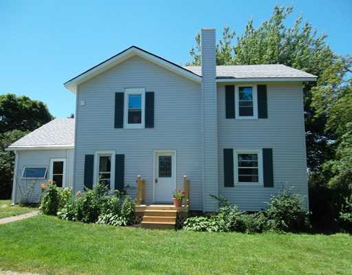
Address: 10675 W LAW RD
Parcel: 37022101000600
Parcel Profile
Address
10675 | W | LAW | RD
Street Status
PAVED
School District
NORTH EAST SCHOOL
Acreage
1.5010
Classification
R
Land Use Code
SINGLE FAMILY
Legal Description
10675 W LAW RD 1.501 AC
Square Feet
2280
Topo
LEVEL
Utility
GAS | WELL | SEPTIC
Zoning
Please contact your municipal zoning officer
Deed Book
2025
Deed Page
016551
2026 Tax Values
Land Value / Taxable
42,300 / 42,300.00
Building Value / Taxable
76,000 / 76,000.00
Total Value / Taxable
118,300 / 118,300.00
Clean & Green
Inactive
Homestead Status
Active
Farmstead Status
Inactive
Lerta Amount
0
Lerta Expiration Year
0
Residential Data
Card 1
Style
OLD STYLE
Basement
FULL
Year Built
1900
Exterior Wall
ALUMINUM/VINYL
Total Living Area
2280
Full Baths
1
Half Baths
0
Fuel Type
GAS
Heating
CENTRAL
Heating System
HOT WATER
Stories
2.0
Total Bedrooms
4
Total Family Rooms
0
Total Rooms
7
Fireplaces
0
Other Buildings & Yards
Description
Built
Width
Length
Area
FLAT BARN
1910
24
40
960
FLAT BARN ADDITION
1910
16
40
640
Sales History
Sale Date
Type
Price
Book / Page
Other Info
9/22/2025
LAND & BUILDING
341000
2025 / 016551
SPECIAL WARRANTY DEED
6/15/2021
LAND & BUILDING
0
2021 / 015320
QUIT CLAIM DEED
9/21/2011
LAND & BUILDING
115000
2011 / 022448
DEED
10/18/2000
0
0732 / 2092
Parcel Sketches
Residential Card 1
A
MAIN
840 square feet
B
1S FR ONE STORY FRAME
600 square feet
C
WDDCK WOOD DECKS
36 square feet
Parcel Images
Please note:
this tab is for informational purposes only and may not show all delinquencies, see the Taxes tab for more accurate delinquent taxes due.