Elected Officials
Courts
Departments
Initiatives
Open Government
About
Login / Register
Home
/
Property & Tax Records
/
Property Records
/
Property & Tax Search
/
Parcel Profile
/
Print View
Search for Another Parcel
Parcel Profile
Historical Card
Sketches
Photos
Tax Map
Taxes
Print View
Print This Page
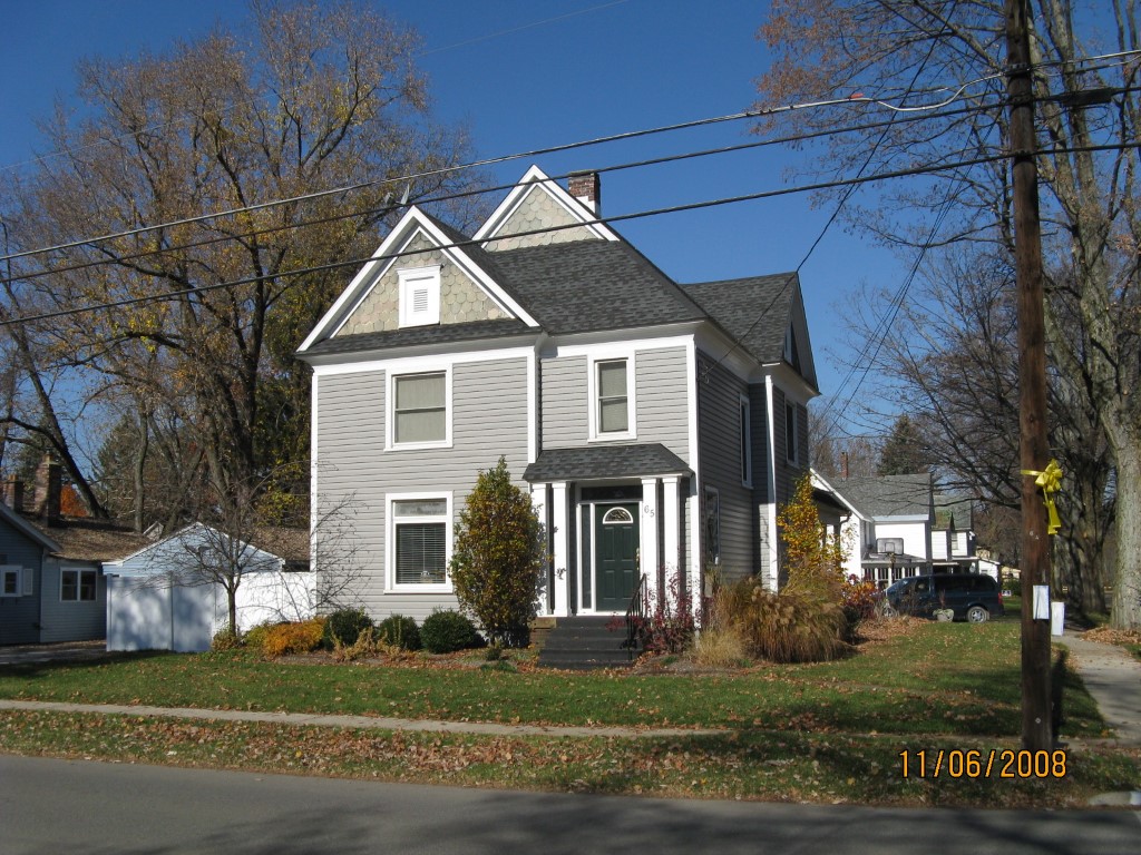
Address: 65 W HIGH ST
Parcel: 42007017000600
Parcel Profile
Address
65 | W | HIGH | ST
Street Status
PAVED | SIDEWALK
School District
UNION CITY AREA SCHOOL
Acreage
0.1869
Classification
R
Land Use Code
SINGLE FAMILY
Legal Description
65 W HIGH ST 69X118
Topo
LEVEL
Utility
ALL PUBLIC
Zoning
Please contact your municipal zoning officer
Deed Book
2025
Deed Page
000541
2026 Tax Values
Land Value / Taxable
12,700 / 12,700.00
Building Value / Taxable
132,520 / 132,520.00
Total Value / Taxable
145,220 / 145,220.00
Clean & Green
Inactive
Homestead Status
Active
Farmstead Status
Inactive
Lerta Amount
0
Lerta Expiration Year
0
Residential Data
Card 1
Style
OLD STYLE
Basement
PART
Year Built
1900
Exterior Wall
ALUMINUM/VINYL
Total Living Area
2636
Full Baths
2
Half Baths
0
Fuel Type
GAS
Heating
CENTRAL
Heating System
HOT WATER
Stories
2.0
Total Bedrooms
4
Total Family Rooms
1
Total Rooms
8
Fireplaces
0
Other Buildings & Yards
No OBY Data Found
Sales History
Sale Date
Type
Price
Book / Page
Other Info
1/10/2025
LAND & BUILDING
181000
2025 / 000541
SPECIAL WARRANTY DEED
5/7/2021
LAND & BUILDING
142500
2021 / 011376
SPECIAL WARRANTY DEED
4/21/2010
LAND & BUILDING
145000
2010 / 008631
DEED
5/22/1998
0
0563 / 0726
2/24/1998
LAND & BUILDING
21600
544 / 1145
Parcel Sketches
Residential Card 1
A
MAIN
856 square feet
B
UNFIN BSMT BASEMENT UNFINISHED 1S FR ONE STORY FRAME 1/2FR FRAME HALF-STORY
528 square feet
C
WDDCK WOOD DECKS
108 square feet
D
EFP ENCL FRAME PORCH
150 square feet
E
OFP OPEN FRAME PORCH
138 square feet
F
OFP OPEN FRAME PORCH
20 square feet
Parcel Images
Please note:
this tab is for informational purposes only and may not show all delinquencies, see the Taxes tab for more accurate delinquent taxes due.