Elected Officials
Courts
Departments
Initiatives
Open Government
About
Login / Register
Home
/
Property & Tax Records
/
Property Records
/
Property & Tax Search
/
Parcel Profile
/
Print View
Search for Another Parcel
Parcel Profile
Historical Card
Sketches
Photos
Tax Map
Taxes
Print View
Print This Page
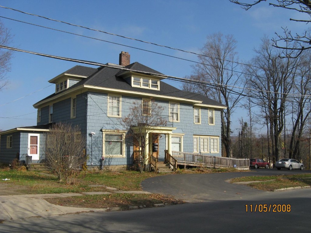
Address: 25 W HIGH ST
Parcel: 42007021000600
Parcel Profile
Address
25 | W | HIGH | ST
Street Status
PAVED | SIDEWALK
School District
UNION CITY AREA SCHOOL
Acreage
0.2332
Classification
E
Land Use Code
EXEMPT NON-PROFIT ORGANIZATIONS
Legal Description
25 W HIGH ST 127.33 X 80
Square Feet
4082
Topo
LEVEL
Utility
ALL PUBLIC
Zoning
Please contact your municipal zoning officer
Deed Book
1182
Deed Page
1983
2026 Tax Values
Land Value / Taxable
13,500 / 13,500.00
Building Value / Taxable
96,450 / 96,450.00
Total Value / Taxable
109,950 / 109,950.00
Clean & Green
Inactive
Homestead Status
Inactive
Farmstead Status
Inactive
Lerta Amount
0
Lerta Expiration Year
0
Residential Data
Card 1
Style
OLD STYLE
Basement
FULL
Year Built
1915
Exterior Wall
COMPOSITION
Total Living Area
4082
Full Baths
2
Half Baths
0
Fuel Type
GAS
Heating
CENTRAL
Heating System
HOT WATER
Stories
2.0
Total Bedrooms
4
Total Family Rooms
0
Total Rooms
13
Fireplaces
0
Other Buildings & Yards
No OBY Data Found
Sales History
Sale Date
Type
Price
Book / Page
Other Info
10/20/2004
LAND & BUILDING
0
1182 / 1983
WARRANTY/SURVIVORSHIP DEED
4/17/2000
0
0698 / 0255
Parcel Sketches
Residential Card 1
A
MAIN
1884 square feet
B
WDDCK WOOD DECKS
48 square feet
C
UNFIN BSMT BASEMENT UNFINISHED 1S FR ONE STORY FRAME
300 square feet
D
OFP OPEN FRAME PORCH
24 square feet
E
FRBAY FRAME BAY
14 square feet
F
WDDCK WOOD DECKS
264 square feet
G
EFP ENCL FRAME PORCH
36 square feet
Parcel Images
Please note:
this tab is for informational purposes only and may not show all delinquencies, see the Taxes tab for more accurate delinquent taxes due.