Elected Officials
Courts
Departments
Initiatives
Open Government
About
Login / Register
Home
/
Property & Tax Records
/
Property Records
/
Property & Tax Search
/
Parcel Profile
/
Print View
Search for Another Parcel
Parcel Profile
Historical Card
Sketches
Photos
Tax Map
Taxes
Print View
Print This Page
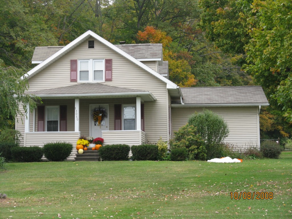
Address: 13050 ROUTE 6
Parcel: 49017043003600
Parcel Profile
Address
13050 | ROUTE 6
Street Status
PAVED
School District
CORRY AREA SCHOOL
Acreage
4.9700
Classification
R
Land Use Code
SINGLE FAMILY
Legal Description
13050 RT 6 PCL 1 4.9751 AC
Square Feet
1694
Topo
LEVEL
Utility
WELL | SEPTIC
Zoning
Please contact your municipal zoning officer
Deed Book
2013
Deed Page
028214
2026 Tax Values
Land Value / Taxable
17,500 / 17,500.00
Building Value / Taxable
135,600 / 135,600.00
Total Value / Taxable
153,100 / 153,100.00
Clean & Green
Inactive
Homestead Status
Active
Farmstead Status
Inactive
Lerta Amount
0
Lerta Expiration Year
0
Residential Data
Card 1
Style
CAPE
Basement
FULL
Year Built
1935
Exterior Wall
ALUMINUM/VINYL
Total Living Area
1694
Full Baths
1
Half Baths
0
Fuel Type
GAS
Heating
CENTRAL
Heating System
FORCED AIR
Stories
1.0
Total Bedrooms
3
Total Family Rooms
0
Total Rooms
6
Fireplaces
0
Other Buildings & Yards
Description
Built
Width
Length
Area
RESIDENTIAL FINISHED OUTBUILD
1995
20
40
800
WOOD/METAL/GLASS ADDITION
1995
12
20
240
Sales History
Sale Date
Type
Price
Book / Page
Other Info
10/25/2013
LAND & BUILDING
175000
2013 / 028214
SPECIAL WARRANTY DEED
3/29/2010
LAND & BUILDING
167000
2010 / 006727
WARRANTY/SURVIVORSHIP DEED
8/28/1995
LAND & BUILDING
67000
400 / 1113
Parcel Sketches
Residential Card 1
A
MAIN
936 square feet
B
OFP OPEN FRAME PORCH
160 square feet
C
EFP ENCL FRAME PORCH
96 square feet
D
FR GR FRAME GARAGE
286 square feet
E
MA_PT CONC/MAS PATIO
144 square feet
F
1S FR ONE STORY FRAME
384 square feet
Parcel Images
Please note:
this tab is for informational purposes only and may not show all delinquencies, see the Taxes tab for more accurate delinquent taxes due.