Elected Officials
Courts
Departments
Initiatives
Open Government
About
Login / Register
Home
/
Property & Tax Records
/
Property Records
/
Property & Tax Search
/
Parcel Profile
/
Print View
Search for Another Parcel
Parcel Profile
Historical Card
Sketches
Photos
Tax Map
Taxes
Print View
Print This Page
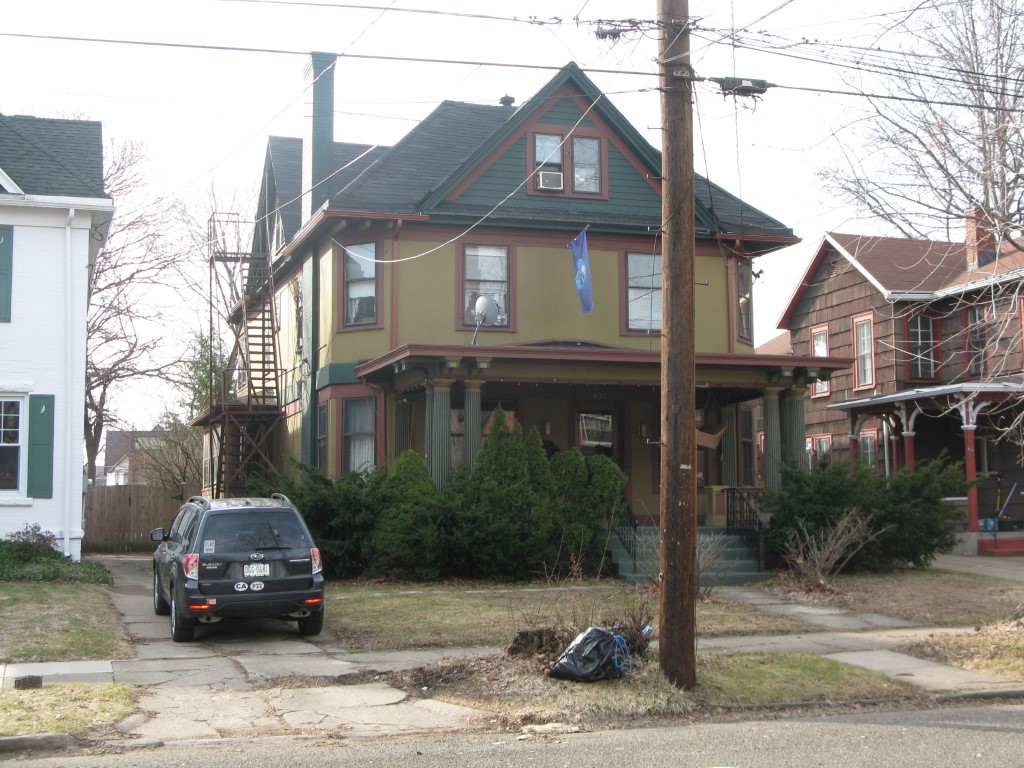
Address: 437 W 7 ST
Parcel: 17040013011700
Parcel Profile
Address
437 | W | 7 | ST
Street Status
PAVED
School District
CITY OF ERIE SCHOOL
Acreage
0.3267
Classification
R
Land Use Code
SINGLE FAMILY
Legal Description
437 W 7 ST 86.25 X 165 | 0.3267 AC
Square Feet
4569
Topo
LEVEL
Utility
ALL PUBLIC
Zoning
Please contact your municipal zoning officer
Deed Book
2022
Deed Page
024933
2026 Tax Values
Land Value / Taxable
10,200 / 10,200.00
Building Value / Taxable
87,300 / 87,300.00
Total Value / Taxable
97,500 / 97,500.00
Clean & Green
Inactive
Homestead Status
Active
Farmstead Status
Inactive
Lerta Amount
0
Lerta Expiration Year
0
Residential Data
Card 1
Style
OLD STYLE
Basement
FULL
Year Built
1904
Exterior Wall
STUCCO
Total Living Area
4569
Full Baths
2
Half Baths
1
Fuel Type
GAS
Heating
CENTRAL
Heating System
HOT WATER
Stories
2.0
Total Bedrooms
4
Total Family Rooms
0
Total Rooms
12
Fireplaces
0
Other Buildings & Yards
No OBY Data Found
Sales History
Sale Date
Type
Price
Book / Page
Other Info
11/23/2022
LAND & BUILDING
0
2022 / 024933
QUIT CLAIM DEED
12/28/2005
LAND & BUILDING
0
1297 / 0192
QUIT CLAIM DEED
7/6/1992
0
0220 / 0912
Parcel Sketches
Residential Card 1
A
MAIN
1747 square feet
B
1S FR ONE STORY FRAME
60 square feet
C
WDDCK WOOD DECKS
158 square feet
D
WDDCK WOOD DECKS
174 square feet
E
UNFIN BSMT BASEMENT UNFINISHED OFP OPEN FRAME PORCH 1S FR ONE STORY FRAME
54 square feet
F
OFP OPEN FRAME PORCH
112 square feet
Parcel Images
Please note:
this tab is for informational purposes only and may not show all delinquencies, see the Taxes tab for more accurate delinquent taxes due.