Elected Officials
Courts
Departments
Initiatives
Open Government
About
Login / Register
Home
/
Property & Tax Records
/
Property Records
/
Property & Tax Search
/
Parcel Profile
/
Print View
Search for Another Parcel
Parcel Profile
Historical Card
Sketches
Photos
Tax Map
Taxes
Print View
Print This Page
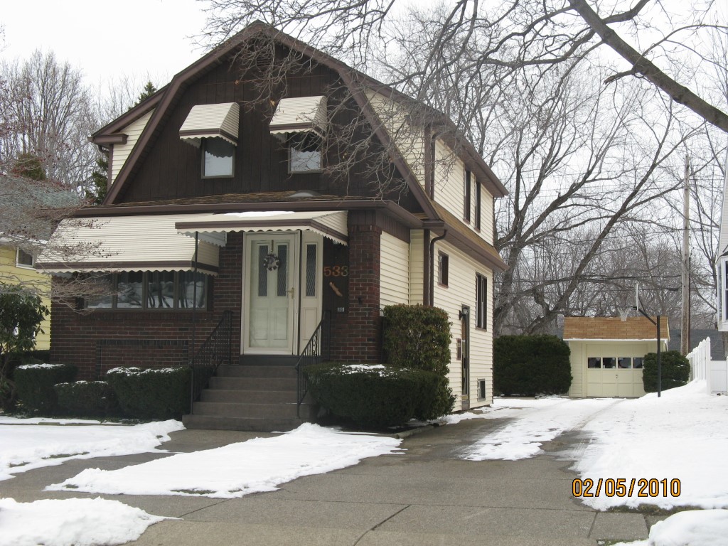
Address: 533 SMITHSON AVE
Parcel: 29013024000601
Parcel Profile
Address
533 | SMITHSON | AVE
Street Status
PAVED | SIDEWALK
School District
IROQUOIS SCHOOL
Acreage
0.1234
Classification
R
Land Use Code
SINGLE FAMILY
Legal Description
533 SMITHSON AVE 43X125
Square Feet
1542
Topo
LEVEL
Utility
ALL PUBLIC
Zoning
Please contact your municipal zoning officer
Deed Book
2018
Deed Page
024560
2026 Tax Values
Land Value / Taxable
20,200 / 20,200.00
Building Value / Taxable
86,700 / 86,700.00
Total Value / Taxable
106,900 / 106,900.00
Clean & Green
Inactive
Homestead Status
Active
Farmstead Status
Inactive
Lerta Amount
0
Lerta Expiration Year
0
Residential Data
Card 1
Style
OLD STYLE
Basement
FULL
Year Built
1928
Exterior Wall
ALUMINUM/VINYL
Total Living Area
1542
Full Baths
2
Half Baths
0
Fuel Type
GAS
Heating
CENTRAL A/C
Heating System
FORCED AIR
Stories
2.0
Total Bedrooms
3
Total Family Rooms
1
Total Rooms
8
Fireplaces
0
Other Buildings & Yards
Description
Built
Width
Length
Area
FRAME OR CB DETACHED GARAGE
1928
12
24
288
Sales History
Sale Date
Type
Price
Book / Page
Other Info
11/29/2018
LAND & BUILDING
116900
2018 / 024560
SPECIAL WARRANTY DEED
12/15/2011
LAND & BUILDING
109000
2011 / 030077
SPECIAL WARRANTY DEED
12/15/2011
LAND & BUILDING
109000
2011 / 030078
DEED
6/10/2010
LAND & BUILDING
111400
2010 / 013561
WARRANTY/SURVIVORSHIP DEED
7/6/1984
0
1542 / 0532
Parcel Sketches
Residential Card 1
A
MAIN
572 square feet
B
1SMAS MASONRY
160 square feet
Parcel Images
Please note:
this tab is for informational purposes only and may not show all delinquencies, see the Taxes tab for more accurate delinquent taxes due.