Elected Officials
Courts
Departments
Initiatives
Open Government
About
Login / Register
Home
/
Property & Tax Records
/
Property Records
/
Property & Tax Search
/
Parcel Profile
/
Print View
Search for Another Parcel
Parcel Profile
Historical Card
Sketches
Photos
Tax Map
Taxes
Print View
Print This Page
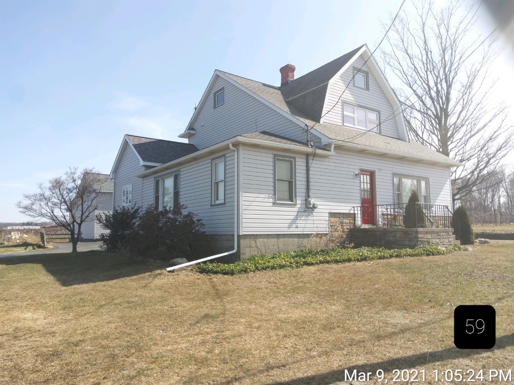
Address: 1391 FREEPORT RD
Parcel: 37005046000100
Parcel Profile
Address
1391 | FREEPORT | RD
Street Status
PAVED
School District
NORTH EAST SCHOOL
Acreage
0.3947
Classification
R
Land Use Code
SINGLE FAMILY
Legal Description
1391 FREEPORT RD 126 X 182 IRR
Square Feet
2333
Topo
LEVEL
Utility
PUBLIC WATER | GAS | SEPTIC
Zoning
Please contact your municipal zoning officer
Deed Book
1612
Deed Page
0433
2026 Tax Values
Land Value / Taxable
33,400 / 33,400.00
Building Value / Taxable
86,000 / 86,000.00
Total Value / Taxable
119,400 / 119,400.00
Clean & Green
Inactive
Homestead Status
Active
Farmstead Status
Inactive
Lerta Amount
0
Lerta Expiration Year
0
Residential Data
Card 1
Style
OLD STYLE
Basement
FULL
Year Built
1915
Exterior Wall
ALUMINUM/VINYL
Total Living Area
2333
Full Baths
1
Half Baths
1
Fuel Type
GAS
Heating
CENTRAL
Heating System
FORCED AIR
Stories
2.0
Total Bedrooms
3
Total Family Rooms
0
Total Rooms
6
Fireplaces
1
Other Buildings & Yards
Description
Built
Width
Length
Area
FLAT BARN
1915
40
30
1200
Sales History
Sale Date
Type
Price
Book / Page
Other Info
12/20/1985
0
1612 / 0433
Parcel Sketches
Residential Card 1
A
MAIN
728 square feet
B
MA STOOP/TERR MAS STOOP
56 square feet
C
UNFIN BSMT BASEMENT UNFINISHED 1S FR ONE STORY FRAME
544 square feet
D
UNFIN BSMT BASEMENT UNFINISHED 1S FR ONE STORY FRAME
156 square feet
E
WDDCK WOOD DECKS
260 square feet
F
FRBAY FRAME BAY
9 square feet
G
1S FR ONE STORY FRAME
168 square feet
Parcel Images
Please note:
this tab is for informational purposes only and may not show all delinquencies, see the Taxes tab for more accurate delinquent taxes due.